Highbridge, Bronx
| Highbridge | |
|---|---|
| Neighborhood of The Bronx | |

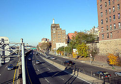
Looking north from 161st Street pedestrian overpass at Major Deegan Expressway
|
|
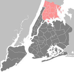
| Location in New York City | |
| Coordinates: 40°50′14″N 73°55′45″W / 40.8372222°N 73.9291667°WCoordinates: 40°50′14″N 73°55′45″W / 40.8372222°N 73.9291667°W | |
| Country |
|
| State |
|
| City |
|
| Borough |
|
| Area | |
| • Total | 1.57 km2 (0.605 sq mi) |
| Population (2010) | |
| • Total | 37,727 |
| • Density | 24,000/km2 (62,000/sq mi) |
| Economics | |
| • Median income | $27,041 |
| ZIP codes | 10452 |
| Area code | 718, 347, 646 |
Highbridge is a residential neighborhood geographically located in the central-west section of the Bronx, New York City. The neighborhood is part of Bronx Community Board 4. Its boundaries, starting from the north and moving clockwise are the Cross-Bronx Expressway to the north, Jerome Avenue to the east, East 161st Street to the south, and the Harlem River to the west. Ogden Avenue is the primary thoroughfare through Highbridge. ZIP codes include 10452. The area is patrolled by the 44th Precinct located at 2 East 169th Street. NYCHA property in the area is patrolled by P.S.A. 7 at 737 Melrose Avenue in the Melrose section of the Bronx.
Based on data from the 2010 United States Census, the population of Highbridge was 37,727, an increase of 3,883 (11.5%) from the 33,844 counted in 2000. Covering an area of 373.14 acres (151.00 ha), the neighborhood had a population density of 101.1 inhabitants per acre (64,700/sq mi; 25,000/km2).
The racial makeup of the neighborhood was 32.9% (12,397) African American, 1.2% (462) White, 0.2% (69) Native American, 0.5% (176) Asian, 0.0% (2) Pacific Islander, 0.3% (103) from other races, and 0.7% (253) from two or more races. Hispanic or Latino of any race were 64.3% (24,265) of the population.
...
Wikipedia


