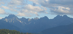
High Tatra Mountains
| High Tatras | |
|---|---|
| Vysoké Tatry | |

Panorama of High Tatras.
Peaks, from left to right: Gerlachovský štít, Batizovský štít, Kačací štít, Končistá, Gánok, Vysoká, and Rysy |
|
| Highest point | |
| Peak | Gerlachovský štít |
| Elevation | 2,655 m (8,711 ft) |
| Coordinates | 49°10′N 20°08′E / 49.167°N 20.133°ECoordinates: 49°10′N 20°08′E / 49.167°N 20.133°E |
| Geography | |
| Countries | Slovakia and Poland |
| States | Prešov Region and Lesser Poland Voivodeship |
| Regions | Tatra National Park—Tatranský národný park (Slovakia) and Tatra National Park—Tatrzański Park Narodowy (Poland) |
| Parent range | Eastern Tatras |
The High Tatras or High Tatra Mountains (Slovak and Czech: Vysoké Tatry, Polish: Tatry Wysokie, Hungarian: Magas-Tátra), are a mountain range along the border of northern Slovakia in the Prešov Region, and southern Poland in the Lesser Poland Voivodeship. They are a range of the Tatra Mountains chain.
The mountain range borders Belianske Tatras to the east, Podtatranská kotlina to the south and Western Tatras to the west. The major part and all the highest peaks of the mountains are situated in Slovakia. The highest peak is Gerlachovský štít, at 2,655 metres (8,711 ft).
The High Tatras, having 29 peaks over 2,500 metres (8,200 ft) AMSL are, with the Southern Carpathians, the only mountain ranges with an alpine character and habitats in the entire 1,200 kilometres (750 mi) length of the Carpathian Mountains system. The first European cross-border national park was founded here—Tatra National Park—with Tatra National Park (Tatranský národný park) in Slovakia in 1948, and Tatra National Park (Tatrzański Park Narodowy) in Poland in 1954. The adjacent parks protect UNESCO's trans-border Tatra Biosphere Reserve.
...
Wikipedia

