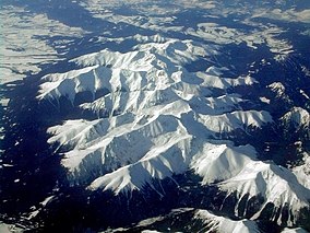
Tatra National Park, Slovakia
| Tatra National Park Tatranský národný park |
|
|---|---|
|
IUCN category II (national park)
|
|

Western Tatras
|
|
| Location | Tatra mountains, North Central Slovakia |
| Coordinates | 49°10′49″N 19°55′10″E / 49.18028°N 19.91944°ECoordinates: 49°10′49″N 19°55′10″E / 49.18028°N 19.91944°E |
| Area | 738 km2 (284.9 mi2) |
| Established | 1 January 1949 |
| Governing body | Správa Tatranského národného parku (The administration of the Tatra National Park) |
Tatra(s) National Park (Slovak: Tatranský národný park; abbr. TANAP) is one of the nine national parks in Slovakia. It is situated in North Central Slovakia in the Tatra Mountains. The park is important for protecting a diverse variety of flora and fauna, with many endemic species, including the Tatra chamois.
The Tatra National Park protects the Slovak areas of the High Tatras mountain range in the Eastern Tatras (Východné Tatry) ranges, and areas of the Western Tatras (Západné Tatry) ranges. The west part of the Tatra National Park is situated in the Žilina Region and the east part in the Prešov Region.
The national park covers an area of 738 km2 (284.9 mi2), and the buffer zone around the park covers an area of 307 km2 (118.5 mi2); 1045 km2 together. The park offers 600 km of hiking trails and 16 marked and maintained bike trails.
The Western Tatras are divided into Osobitá, Roháče, Sivý vrch (literally Grey Mountain), Liptovské Tatry (Liptov Tatras), Liptovské Kopy, Červené vrchy (Red Mountains). The Eastern Tatras consist of High Tatras (Vysoké Tatry) and Belianske Tatras (Belianske Tatry).
The highest peak in Slovakia at 2,655 metres (8,711 ft) in elevation, Gerlachovský štít, is located within the park. It is also the highest point in the Tatra Mountains and the Carpathian Mountains. Bystrá is the highest mountain in the Western Tatras at 2,248 metres (7,375 ft), and Havran mountain (English: Raven) is the highest point in the Belianske Tatras at 2,152 metres (7,060 ft).
...
Wikipedia
