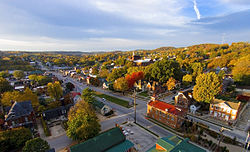
Hermann, Missouri
| Hermann, Missouri | ||
|---|---|---|
| City | ||

Early morning sun lights up the fall colors down Market Street in Hermann, Missouri
|
||
|
||
| Nickname(s): Deutschheim | ||
 Location of Hermann, Missouri |
||
| Coordinates: 38°41′57″N 91°26′21″W / 38.69917°N 91.43917°WCoordinates: 38°41′57″N 91°26′21″W / 38.69917°N 91.43917°W | ||
| Country | United States | |
| State | Missouri | |
| County | Gasconade | |
| Established | 1837 | |
| Government | ||
| • Type | Mayor/Alderman/Administrator | |
| • Mayor | Robert Koerber | |
| • Administrator | Mark Wallace | |
| Area | ||
| • Total | 2.71 sq mi (7.02 km2) | |
| • Land | 2.53 sq mi (6.55 km2) | |
| • Water | 0.18 sq mi (0.47 km2) | |
| Elevation | 531 ft (162 m) | |
| Population (2010) | ||
| • Total | 2,431 | |
| • Estimate (2012) | 2,393 | |
| • Density | 960.9/sq mi (371.0/km2) | |
| Time zone | Central (CST) (UTC-6) | |
| • Summer (DST) | CDT (UTC-5) | |
| ZIP code | 65041 | |
| Area code(s) | 573 | |
| FIPS code | 29-31762 | |
| GNIS feature ID | 0719397 | |
| Website |
www.hermannmo.com www.visithermann.com |
|
Hermann is a city designated in 1842 as the county seat of Gasconade County, Missouri, United States. It is near the center of the Missouri Rhineland and south of the Missouri River. The population was 2,431 at the 2010 census.
The city is the commercial center of the Hermann American Viticultural Area, whose seven wineries produce about one-third of the state's wine. Designated in 1983, it is one of the first federally recognized American Viticultural Areas. The designation recognized the renaissance of an area of vineyards and wineries established by German immigrants during the mid-19th century. Shut down by Prohibition, it began to revive in the 1960s.
Hermann holds a Maifest during the third weekend in May and an Oktoberfest the first four weekends in October. Hermann also calls itself the sausage-making capital of Missouri.
The city was founded by the Deutsche Ansiedlungs-Gesellschaft zu Philadelphia (German Settlement Society of Philadelphia) in 1837. It was promoted by Gottfried Duden, who wrote about the area in his Bericht über eine Reise nach den westlichen Staaten Nord Amerikas (Report of a Journey to the Western States of Northern America). An early group of settlers were led by George Bayer and Edward Hermann, who bought the land and is considered by many to be the founder of the town. The town was platted after the society sold shares in the 11,300 acres (4,600 ha) of Gasconade River valley land it had purchased.
The society had almost utopian goals of a "heart of German-America" where it could perpetuate traditional German culture and establish a self-supporting colony built around farming, commerce, and industry. The town is named after Hermann der Cherusker, a Germanic leader who defeated the Romans in the Battle of the Teutoburg Forest in the year 9. In 2009, Hermann celebrated the 2000th anniversary of the battle, in which the Germanic warrior Hermann defeated three Roman legions.
...
Wikipedia

