Heraklion
|
Heraklion Ηράκλειο |
||
|---|---|---|

The Venetian fortress of Rocca al Mare (1523–1540) guards the inner harbor of Heraklion.
|
||
|
||
| Coordinates: 35°20′N 25°8′E / 35.333°N 25.133°ECoordinates: 35°20′N 25°8′E / 35.333°N 25.133°E | ||
| Country | Greece | |
| Administrative region | Crete | |
| Regional unit | Heraklion | |
| Government | ||
| • Mayor | Vasilis Labrinos | |
| Area | ||
| • Municipality | 244.6 km2 (94.4 sq mi) | |
| • Municipal unit | 109.0 km2 (42.1 sq mi) | |
| Highest elevation | 33 m (108 ft) | |
| Lowest elevation | 0 m (0 ft) | |
| Population (2011) | ||
| • Municipality | 173,993 | |
| • Municipality density | 710/km2 (1,800/sq mi) | |
| • Municipal unit | 151,324 | |
| • Municipal unit density | 1,400/km2 (3,600/sq mi) | |
| Time zone | EET (UTC+2) | |
| • Summer (DST) | EEST (UTC+3) | |
| Postal code | 70x xx, 71x xx, 720 xx | |
| Area code(s) | 281 | |
| Vehicle registration | HK, HP | |
| Website | www.heraklion-city.gr | |
Heraklion (/hᵻˈrækliən/, Greek: Ηράκλειο, Irákleio, pronounced [iˈraklio]) is the largest city and the administrative capital of the island of Crete. It is the fourth largest city in Greece. According to the results of the 2011 census, the population of the city proper was 140,730 inhabitants, the municipality's was 173,993 while the Heraklion urban area has a population of 225,574 and it extends over an area of 684.3 km2 (264.2 sq mi).
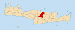
Heraklion is the capital of Heraklion regional unit.
The Bronze Age palace of Knossos, also known as the Palace of Minos, is located nearby.
The Arab raiders from Andalusia (Iberia) who founded the Emirate of Crete moved the island's capital from Gortyna to a new castle they called ربض الخندق rabḍ al-ḫandaq 'Castle of the Moat' in the 820s. This was hellenized as Χάνδαξ (Khándax) or Χάνδακας (Khándakas) and Latinized as Candia, which was taken into other European languages: in Italian and Latin as Candia, in French as Candie, in English as Candy, all of which could refer to the island of Crete as a whole as well as to the city alone; the Ottoman name was Kandiye.
...
Wikipedia


