Henry Coe State Park
| Henry W. Coe State Park | |
|---|---|
|
IUCN category II (national park)
|
|

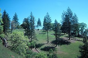
Ponderosa Pines on summit of Pine Ridge
|
|
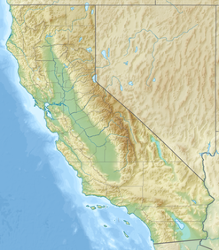
| Location | Santa Clara and Stanislaus Counties, California, USA |
| Nearest city | Morgan Hill, California |
| Coordinates | 37°11′18″N 121°32′42″W / 37.18833°N 121.54500°WCoordinates: 37°11′18″N 121°32′42″W / 37.18833°N 121.54500°W |
| Area | 89,164 acres (360.83 km2) |
| Established | 1959 |
| Visitors | 34,395 (in 2006) |
| Governing body | California Department of Parks and Recreation |
| Henry W. Coe State Wilderness (Orestimba Wilderness) | |
|---|---|
|
IUCN category Ib (wilderness area)
|
|
| Location | Santa Clara and Stanislaus Counties, California, USA |
| Nearest city | Morgan Hill, California |
| Coordinates | 37°13′17″N 121°23′34″W / 37.22139°N 121.39278°W |
| Area | 22,000 acres (89 km2) |
| Established | 1985 |
| Governing body | California Department of Parks & Recreation |
Henry W. Coe State Park (or Coe Park for short) is a state park of California, USA, preserving a vast tract of the Diablo Range. The park is located closest to the city of Morgan Hill, and is located in both Santa Clara and Stanislaus counties. The park contains over 89,000 acres (36,000 ha), making it the largest state park in northern California, and the second-largest in the state (after Anza-Borrego Desert State Park). Managed within its boundaries is a designated wilderness area of about 22,000 acres (8,900 ha). This is officially known as the Henry W. Coe State Wilderness, but locally as the Orestimba Wilderness. The 89,164-acre (36,083 ha) park was established in 1959.
Prior to its use as ranch land, the Diablo Range backcountry now covered by Henry W. Coe State Park was traversed by La Vereda del Monte, a trail between the Central Valley and Point of Timber on the Sacramento River Delta. Joaquin Murrieta and his gang used the route to drive stolen horses south from Contra Costa County, passing into the area via the San Antonio Valley. Horses were held at several locations now contained within the park, including Mustang Flat and Coit Camp. Both Mustang Peak and Mustang Flat derive their names from the activities of Murrieta and his gang.
The park began as the Pine Ridge Ranch, a private cattle ranch of 12,230 acres (4,950 ha). It was the home of Henry Willard Coe, Jr. and his family from 1905 until his death in 1943. Coe left the ranch to his son, Henry Sutcliffe Coe, who sold it to the Beach Land and Cattle Company of Fresno County in 1948. The ranch's road network was greatly expanded during this time. Coe's daughter, Sada Coe Robinson, re-purchased the ranch in 1950 and donated it to Santa Clara County in 1953, when it became Henry Willard Coe County Park. It became a state park in 1958. Additional adjacent lands were added, and for many years, the park's size stood at 13,000 acres (5,300 ha). Indeed, many currently available state road maps still show the park in its 13,000 acre configuration. The park expanded considerably in the early 1980s with the purchase of adjacent properties to the east and south (the Gill-Mustang and Coit ranches, respectively), bringing the size to 67,000 acres (27,000 ha)). In the early 1990s the Redfern Ranch added some 11,000 acres (4,500 ha) in the south, and since 2000 lands to the west have been purchased for inclusion. The park is still growing.
...
Wikipedia


