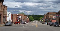
Henderson, Minnesota
| Henderson, Minnesota | |
|---|---|
| City | |
 |
|
 Location of Henderson within Sibley County, Minnesota |
|
| Coordinates: 44°31′44″N 93°54′28″W / 44.52889°N 93.90778°W | |
| Country | United States |
| State | Minnesota |
| County | Sibley |
| Government | |
| • Type | Mayor-council |
| • Mayor | Paul Menne |
| Area | |
| • Total | 1.09 sq mi (2.82 km2) |
| • Land | 1.06 sq mi (2.75 km2) |
| • Water | 0.03 sq mi (0.08 km2) |
| Elevation | 755 ft (230 m) |
| Population (2010) | |
| • Total | 886 |
| • Estimate (2012) | 878 |
| • Density | 835.8/sq mi (322.7/km2) |
| Time zone | Central (CST) (UTC-6) |
| • Summer (DST) | CDT (UTC-5) |
| ZIP code | 56044 |
| Area code(s) | 507 |
| FIPS code | 27-28394 |
| GNIS feature ID | 0644862 |
| Website | www |
Henderson is a city in Sibley County, Minnesota, United States. The population was 886 at the 2010 census.
Henderson was founded in August 1852 by Joseph R. Brown, and was named for his mother's maiden name.
By 1855, Henderson had become a fast-growing city as it already harbored more 60 buildings including a hotel, a warehouse, a steam sawmill, as well as Brown's house which functioned as a boarding house, a store and a residence for the Brown family. Henderson quickly became a major distribution center for the inland settlements surrounding the Minnesota River Valley in the following years.
By the mid-1860s Henderson had two major brickyards, The Mattei and Schwartz Brickyard, who both contributed heavily to the early 1900s brick-style buildings still present in Henderson today.
After various petitions by Gaylord from as far back as 1887 to gain the county seat of Sibley County, the county seat was finally offered to Gaylord in 1915 by a county-wide vote. This caused a major decline of around 200 residents leaving Henderson. Throughout the 50 years after this population loss, Henderson's economy became increasingly more centered on agriculture that largely sustain the downtown after the loss of the county seat. Its success in changing support has brought rise to the Sauerkraut Days celebrated today.
According to the United States Census Bureau, the city has a total area of 1.09 square miles (2.82 km2); 1.06 square miles (2.75 km2) is land and 0.03 square miles (0.08 km2) is water.
Minnesota State Highways 19 and 93 are two of the main routes in the community. U.S. Highway 169 is nearby.
As of 2000 the median income for a household in the city was $43,125, and the median income for a family was $49,091. Males had a median income of $31,736 versus $25,688 for females. The per capita income for the city was $17,544. About 4.7% of families and 6.6% of the population were below the poverty line, including 8.7% of those under age 18 and 9.7% of those age 65 or over.
...
Wikipedia
