Hendaia
| Hendaye | ||
|---|---|---|
| Commune | ||

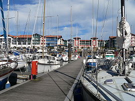
Hendaye harbour
|
||
|
||
| Coordinates: 43°22′N 1°46′W / 43.36°N 1.77°WCoordinates: 43°22′N 1°46′W / 43.36°N 1.77°W | ||
| Country | France | |
| Region | Nouvelle-Aquitaine | |
| Department | Pyrénées-Atlantiques | |
| Arrondissement | Bayonne | |
| Canton | Hendaye-Côte Basque-Sud | |
| Intercommunality | CA Pays Basque | |
| Government | ||
| • Mayor (2014–2020) | Kotte Écénarro | |
| Area1 | 8 km2 (3 sq mi) | |
| Population (2013)2 | 16,887 | |
| • Density | 2,100/km2 (5,500/sq mi) | |
| Time zone | CET (UTC+1) | |
| • Summer (DST) | CEST (UTC+2) | |
| INSEE/Postal code | 64260 /64700 | |
| Elevation | 0–108 m (0–354 ft) (avg. 25 m or 82 ft) |
|
|
1 French Land Register data, which excludes lakes, ponds, glaciers > 1 km² (0.386 sq mi or 247 acres) and river estuaries. 2Population without double counting: residents of multiple communes (e.g., students and military personnel) only counted once. |
||
1 French Land Register data, which excludes lakes, ponds, glaciers > 1 km² (0.386 sq mi or 247 acres) and river estuaries.
Hendaye (Basque: Hendaia) is a commune in the Pyrénées-Atlantiques department and Nouvelle-Aquitaine region of southwestern France.
The town, France's most southwesterly and a popular seaside tourist resort, stands on the right bank of the River Bidassoa – which marks the Franco-Spanish border – at the point where it empties into the Atlantic Ocean in the French Basque Country.
Hendaye has three distinguishable parts: la ville (the town), which stretches from Saint Vincent's church to the area around the SNCF railway station and the industrial zone; la plage (the beach), the seaside quarter; and les hauteurs (the heights), the villas and camping sites on the hills between and behind the other two areas.
Hendaye acquired its independence from the Urrugne parish in 1598, when Saint Vincent's church was built. In the Franco-Spanish War, the town was briefly occupied by the Spanish, in September 1636.
On the fortified Île des Faisans ("Pheasant Island") in the river, the Treaty of the Pyrenees was signed in 1659, ending decades of intermittent war between France and Spain. Authority over the Île changes between France and Spain every six months.
All the same, the village kept being subject to destruction due to cross-border military activity. In the War of the Pyrenees (1793-1795), or less possibly in the run-up to the rise of Napoleon to prominence, the village was levelled to the ground, as described in 1799 by Wilhelm von Humboldt: "The settlement spreads over a rather wide area, and seems to have looked clean and pleasant time ago. Currently all the houses, but for a handful of them, lie destroyed. The empty walls can barely stand, while the ground before inhabited is covered with overgrown bush and hawthorn. Ivy creeps up the walls, out of crumbling windows the desolate ocean can be seen through the room. Shells can still be come across the street here and there, but hardly ever can one bump into a person. Most of the inhabitants either perished in the danger and helplessness of the runaway, or they scattered away to other places."
...
Wikipedia


