Hazelhurst, Michigan
| Shorewood-Tower Hills-Harbert, Michigan | |
|---|---|
| Census-designated place | |

Cottage near Lake Michigan in Shorewood Hills, c. 1950
|
|
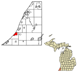
 Location of Shorewood-Tower Hills-Harbert, Michigan |
|
| Coordinates: 41°53′11″N 86°37′4″W / 41.88639°N 86.61778°WCoordinates: 41°53′11″N 86°37′4″W / 41.88639°N 86.61778°W | |
| Country | United States |
| State | Michigan |
| County | Berrien |
| Area | |
| • Total | 4.6 sq mi (11.8 km2) |
| • Land | 4.5 sq mi (11.7 km2) |
| • Water | 0.04 sq mi (0.1 km2) |
| Population (2010) | |
| • Total | 1,344 |
| • Density | 297/sq mi (114.7/km2) |
| Time zone | Eastern (EST) (UTC-5) |
| • Summer (DST) | EDT (UTC-4) |
| FIPS code | 26-73730 |
Shorewood-Tower Hills-Harbert is a census-designated place (CDP) composed of several small unincorporated communities in Chikaming Township of Berrien County in the U.S. state of Michigan. The population was 1,344 at the 2010 census. The CDP is limited to Chikaming Township, although some of the communities extend into southern Lake Township. All of the communities are located either upon or just east of the dunes on the shore of Lake Michigan. Most of the communities lie west of Interstate 94, although the CDP includes a small area east of the freeway up to Sawyer.
According to the United States Census Bureau, the CDP has a total area of 4.6 square miles (11.8 km2), of which 4.5 square miles (11.7 km2) is land and 0.04 square miles (0.1 km2), or 0.71%, is water.
As of the census of 2000, there were 1,619 people, 725 households, and 484 families residing in the CDP. The population density was 356.9 per square mile (137.7/km²). There were 1,519 housing units at an average density of 334.8 per square mile (129.2/km²). The racial makeup of the CDP was 97.10% White, 0.86% Black or African American, 0.31% Native American, 0.25% Asian, 0.06% Pacific Islander, 0.49% from other races, and 0.93% from two or more races. Hispanic or Latino of any race were 1.24% of the population.
...
Wikipedia
