Chikaming Township, Michigan
| Chikaming Township, Michigan | |
|---|---|
| Township | |

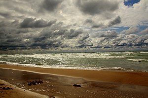
Lake Michigan from the beach at Harbert
|
|
| Location within the state of Michigan | |
| Coordinates: 41°51′54″N 86°38′10″W / 41.86500°N 86.63611°WCoordinates: 41°51′54″N 86°38′10″W / 41.86500°N 86.63611°W | |
| Country | United States |
| State | Michigan |
| County | Berrien |
| Area | |
| • Total | 22.1 sq mi (57.3 km2) |
| • Land | 21.9 sq mi (56.8 km2) |
| • Water | 0.2 sq mi (0.5 km2) |
| Elevation | 640 ft (195 m) |
| Population (2010) | |
| • Total | 3,100 |
| • Density | 141/sq mi (54.6/km2) |
| Time zone | Eastern (EST) (UTC-5) |
| • Summer (DST) | EDT (UTC-4) |
| FIPS code | 26-15480 |
| GNIS feature ID | 1626076 |
| Website | www |
Chikaming Township is a civil township of Berrien County in the U.S. state of Michigan. As of the 2010 census, the township population was 3,100. The township is located in the west central portion of the county. Lake Michigan lies to the northwest, Lake Township is to the north and northeast, Weesaw Township is to the east, Three Oaks Township is to the south, and New Buffalo Township is to the southwest.
Chickaming Township was established in 1856. The first township supervisor was Silas Sawyer.
The unincorporated communities of Sawyer, Harbert, and Lakeside are all within the township, and Union Pier is partially located in both Chikaming and New Buffalo Township. The U.S. Census Bureau recognizes the Shorewood-Tower Hills-Harbert census-designated place in the northern third of the township for statistical purposes.
According to the United States Census Bureau, the township has a total area of 22.1 square miles (57.3 km2), of which 21.9 square miles (56.8 km2) is land and 0.19 square miles (0.5 km2), or 0.83%, is water.
Interstate 94 passes northeast-southwest through the township, parallel to the Lake Michigan shoreline.
...
Wikipedia

