Haynes, North Dakota
| Haynes, North Dakota | |
|---|---|
| City | |

Haynes, North Dakota
|
|
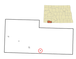
 Location of Haynes, North Dakota |
|
| Coordinates: 45°58′25″N 102°28′19″W / 45.97361°N 102.47194°WCoordinates: 45°58′25″N 102°28′19″W / 45.97361°N 102.47194°W | |
| Country | United States |
| State | North Dakota |
| County | Adams |
| Founded | 1907 |
| Area | |
| • Total | 0.14 sq mi (0.36 km2) |
| • Land | 0.14 sq mi (0.36 km2) |
| • Water | 0 sq mi (0 km2) |
| Elevation | 2,546 ft (776 m) |
| Population (2010) | |
| • Total | 23 |
| • Estimate (2015) | 22 |
| • Density | 164.3/sq mi (63.4/km2) |
| Time zone | Mountain (MST) (UTC-7) |
| • Summer (DST) | MDT (UTC-6) |
| ZIP code | 58639 |
| Area code(s) | 701 |
| FIPS code | 38-36540 |
| GNIS feature ID | 1029356 |
Haynes is a city in Adams County, North Dakota, United States. The population was 23 at the 2010 census.
Haynes was founded as Gadsden in 1906 along the Milwaukee Road's transcontinental rail line known as the Pacific Extension. The name was changed to Haynes in 1907 to honor George B. Haynes, president of the Milwaukee Road at the time.
Haynes is located at 45°58′25″N 102°28′19″W / 45.97361°N 102.47194°W (45.973722, -102.471990).
According to the United States Census Bureau, the city has a total area of 0.14 square miles (0.36 km2), all of it land.
At the 2010 census, there were 23 people, 13 households and 6 families residing in the city. The population density was 164.3 inhabitants per square mile (63.4/km2). There were 16 housing units at an average density of 114.3 per square mile (44.1/km2). The racial makeup of the city was 78.3% White and 21.7% Native American.
There were 13 households of which 7.7% had children under the age of 18 living with them, 46.2% were married couples living together, and 53.8% were non-families. 46.2% of all households were made up of individuals and 7.7% had someone living alone who was 65 years of age or older. The average household size was 1.77 and the average family size was 2.50.
...
Wikipedia
