Hayesville, Ohio
| Hayesville, Ohio | |
|---|---|
| Village | |

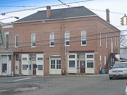
Village Hall
|
|
 Location of Hayesville, Ohio |
|
 Location of Hayesville in Ashland County |
|
| Coordinates: 40°46′26″N 82°15′42″W / 40.77389°N 82.26167°WCoordinates: 40°46′26″N 82°15′42″W / 40.77389°N 82.26167°W | |
| Country | United States |
| State | Ohio |
| County | Ashland |
| Area | |
| • Total | 0.74 sq mi (1.92 km2) |
| • Land | 0.74 sq mi (1.92 km2) |
| • Water | 0 sq mi (0 km2) |
| Elevation | 1,240 ft (378 m) |
| Population (2010) | |
| • Total | 448 |
| • Estimate (2012) | 446 |
| • Density | 605.4/sq mi (233.7/km2) |
| Time zone | Eastern (EST) (UTC-5) |
| • Summer (DST) | EDT (UTC-4) |
| ZIP code | 44838 |
| Area code(s) | 419 |
| FIPS code | 39-34636 |
| GNIS feature ID | 1064816 |
Hayesville is a village in Ashland County, Ohio, United States. The population was 448 at the 2010 census.
The first settlers came to the Hayesville area in 1817. A post office for the settlers was established in 1827 at Hayes Cross Roads. Hayesville was laid out in Vermillion Township and plots were recorded in Mansfield, Ohio on October 26, 1830. The village was named after Linus Hayes, proprietor. Hayes Cross Roads was later renamed Hayesville. The village of Hayesville was incorporated in 1849.
Hayesville is located at 40°46′26″N 82°15′42″W / 40.77389°N 82.26167°W (40.773853, -82.261753).
According to the United States Census Bureau, the village has a total area of 0.74 square miles (1.92 km2), all land.
Hayesville Ohio Townhall-Old Opera House
As of the census of 2010, there were 448 people, 184 households, and 135 families residing in the village. The population density was 605.4 inhabitants per square mile (233.7/km2). There were 192 housing units at an average density of 259.5 per square mile (100.2/km2). The racial makeup of the village was 98.4% White, 0.2% Asian, and 1.3% from two or more races. Hispanic or Latino of any race were 0.4% of the population.
...
Wikipedia
