Hawaii Route 19
| Hawaiʻi Belt Road | ||||||||||
|---|---|---|---|---|---|---|---|---|---|---|
| Māmalahoa Highway | ||||||||||

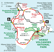
Map of the Island of Hawaiʻi with the Hawaiʻi Belt Road highlighted in red
|
||||||||||
| Route information | ||||||||||
| Maintained by HDOT and HCDPW | ||||||||||
| Length: | 150.7 mi (242.5 km) 122.2 mi (196.66 km) via Route 11 99.8 mi (160.61 km) via Route 19 38.7 mi (62.28 km) via Route 190 |
|||||||||
| Existed: | 1783 – present | |||||||||
| History: | Completed in 1975 | |||||||||
| Component highways: |
|
|||||||||
| Major junctions | ||||||||||
| Beltway around the Island of Hawaiʻi | ||||||||||
|
|
||||||||||
| Highway system | ||||||||||
|
||||||||||
The Hawaiʻi Belt Road is a modern name for the Māmalahoa Highway and consists of Hawaiʻi state Routes 11, 19, and 190 that encircle the Island of Hawaiʻi. The southern section, between Hilo and Kailua-Kona is numbered as Route 11. The section between Hilo and Waimea is Route 19. Between Waimea and Kailua-Kona, the road is split in two: the original "mauka" route (now Route 190) and a "makai" Route 19, completed in 1975, which serves as access to the Kona and Kohala Coast resorts. In the Hawaiian language, mauka means "towards the mountain" and makai means "towards the sea". These terms are commonly used in travel directions.
Parts of the southern half of the Hawaiʻi Belt Road were known during the Territorial days as the Kaʻū Belt Road. The names "Hawaiʻi Belt Road" and "Māmalahoa Highway" refer to the road system that encircles the entire island; many sections are also referenced by local names.
...
Wikipedia


