Haultain, Ontario
| North Kawartha | |
|---|---|
| Township (lower-tier) | |
| Township of North Kawartha | |

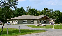
Municipal office in Apsley
|
|
| Coordinates: 44°45′N 78°06′W / 44.750°N 78.100°WCoordinates: 44°45′N 78°06′W / 44.750°N 78.100°W | |
| Country |
|
| Province |
|
| County | Peterborough |
| Incorporated | January 1, 1998 |
| Government | |
| • Type | Township |
| • Reeve | Rick Woodcock |
| • Federal riding | Peterborough-Kawartha |
| • Prov. riding | Haliburton—Kawartha Lakes—Brock |
| Area | |
| • Land | 776.04 km2 (299.63 sq mi) |
| Population (2011) | |
| • Total | 2,289 |
| • Density | 2.9/km2 (8/sq mi) |
| Time zone | EST (UTC-5) |
| • Summer (DST) | EDT (UTC-4) |
| Postal Code | K0L 1A0 |
| Area code(s) | 705 & 249 |
| Website | www.northkawartha.on.ca |
North Kawartha is a township in northern Peterborough County, Ontario, Canada.
North Kawartha was formed in 1998 through an amalgamation of the Townships of Burleigh and Anstruther and the Township of Chandos. For a while after this merger, it was known as Burleigh-Anstruther-Chandos.
The township comprises the communities of Apsley (main village), Big Cedar, Glen Alda, Rose Island, Woodview and part of Burleigh Falls. These communities are surrounded by freshwater lakes including Chandos, Jack's, Anstruther, Eels, and many more.
The local government is the Corporation of the Township of North Kawartha. The current mayor is Rick Woodcock.
According to the 2006 Canada Census, the township is home to 2,342 residents, making it the smallest municipality in Peterborough County in terms of population, though the seasonal population is estimated at 12,000. The population grew by 9.2% between the 2001 and 2006 censuses. The area of the township 765.02 km² and has a population density of 3.1 per square kilometre. Private dwellings occupied by usual residents amount to 1054 (total dwellings: 3433). Mother tongue spoken by its population are:
Population trend:
...
Wikipedia

