Hattah-Kulkyne National Park
|
Hattah-Kulkyne National Park Victoria |
|
|---|---|
|
IUCN category II (national park)
|
|

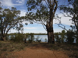
Hattah Lake, within the national park.
|
|
| Nearest town or city | Mildura |
| Coordinates | 34°41′14″S 142°22′54″E / 34.68722°S 142.38167°ECoordinates: 34°41′14″S 142°22′54″E / 34.68722°S 142.38167°E |
| Established | 7 June 1960 |
| Area | 480 km2 (185.3 sq mi) |
| Managing authorities | Parks Victoria |
| Website | Hattah-Kulkyne National Park |
| See also | Protected areas of Victoria |
The Hattah-Kulkyne National Park is a national park in the Mallee district of Victoria, Australia. The 48,000-hectare (120,000-acre) national park is situated adjacent to the Murray River, approximately 417 kilometres (259 mi) northwest of Melbourne with the nearest regional centre being Mildura. The national park was proclaimed on 7 June 1960 and is a popular destination for bushwalkers and school camping trips.
The park is in the Mallee district, famous for its red dirt and semi-arid shrub-like vegetation, mainly eucalypts. There are several lakes in the area, the largest of which is Lake Hattah. During the dry season most of the lakes and their streams dry out completely. Although there are limited road and tracks, there are several major high tension power and telegraph lines that run through or near the park, around which large areas are cleared. For management purposes, the Hattah-Kulkyne National Park is managed with the Murray-Sunset National Park, Wyperfeld National Park, Lake Albacutya Park and Murray-Kulkyne Park as part of the Victorian Mallee Parks.
Over 200 bird species have been recorded in the park, which is overlapped by the Murray-Sunset, Hattah and Annuello Important Bird Area (IBA), so identified by BirdLife International because it contains mallee habitat supporting a suite of threatened mallee bird, including the malleefowl, black-eared miner and mallee emu-wren.
...
Wikipedia

