Hasbrouck Heights
| Hasbrouck Heights, New Jersey | |
|---|---|
| Borough | |
| Borough of Hasbrouck Heights | |

The Bendix Diner, a prominent landmark on Route 17
|
|
 Map highlighting Hasbrouck Heights' location within Bergen County. Inset: Bergen County's location within New Jersey |
|
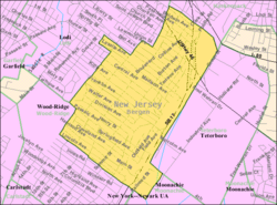
 Census Bureau map of Hasbrouck Heights, New Jersey |
|
| Coordinates: 40°51′46″N 74°04′31″W / 40.862751°N 74.075182°WCoordinates: 40°51′46″N 74°04′31″W / 40.862751°N 74.075182°W | |
| Country | |
| State |
|
| County | Bergen |
| Incorporated | July 31, 1894 |
| Named for | J. D. Hasbrouck |
| Government | |
| • Type | Borough |
| • Body | Borough Council |
| • Mayor | John "Jack" DeLorenzo III (R, term ends December 31, 2019) |
| • Administrator | Michael Kronyak |
| • Municipal clerk | Rose Marie Sees |
| Area | |
| • Total | 1.510 sq mi (3.910 km2) |
| • Land | 1.506 sq mi (3.899 km2) |
| • Water | 0.004 sq mi (0.010 km2) 0.26% |
| Area rank | 450th of 566 in state 58th of 70 in county |
| Elevation | 112 ft (34 m) |
| Population (2010 Census) | |
| • Total | 11,842 |
| • Estimate (2016) | 12,182 |
| • Rank | 205th of 566 in state 27th of 70 in county |
| • Density | 7,865.4/sq mi (3,036.8/km2) |
| • Density rank | 47th of 566 in state 13th of 70 in county |
| Time zone | Eastern (EST) (UTC-5) |
| • Summer (DST) | Eastern (EDT) (UTC-4) |
| ZIP code | 07604 |
| Area code(s) | 201 exchanges: 288, 393, 462, 727 |
| FIPS code | 3400330420 |
| GNIS feature ID | 0885247 |
| Website | www |
Hasbrouck Heights (pronounced HAZ-brook /ˈhæz.bɹʊk/) is a borough in Bergen County, New Jersey, United States. As of the 2010 United States Census, the borough's population was 11,842, reflecting an increase of 180 (+1.5%) from the 11,662 counted in the 2000 Census, which had in turn increased by 174 (+1.5%) from the 11,488 counted in the 1990 Census. An inner-ring suburb of New York City, Hasbrouck Heights is located approximately 10 miles (16 km) northwest of Midtown Manhattan and 8 miles (13 km) west of Upper Manhattan.
Hasbrouck Heights was formed by an act of the New Jersey Legislature on August 2, 1894, based on the passage of a referendum on July 31, 1894, and was created from portions of Lodi Township at the height of the "Boroughitis" phenomenon then sweeping through Bergen County. A part of the borough was annexed to Lodi in 1901.
The borough was named for J. D. Hasbrouck of the New Jersey and New York Railroad.
According to the United States Census Bureau, the borough had a total area of 1.510 square miles (3.910 km2), including 1.506 square miles (3.899 km2) of land and 0.004 square miles (0.010 km2) of water (0.26%) was water.
The borough borders Hackensack, Lodi, Moonachie, Teterboro and Wood-Ridge.
...
Wikipedia
