Wood-Ridge, New Jersey
| Wood-Ridge, New Jersey | |
|---|---|
| Borough | |
| Borough of Wood-Ridge | |
 Map highlighting Wood-Ridge's location within Bergen County. Inset: Bergen County's location within New Jersey. |
|
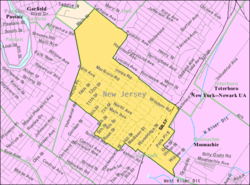
 Census Bureau map of Wood-Ridge, New Jersey |
|
| Coordinates: 40°51′01″N 74°05′13″W / 40.850183°N 74.087068°WCoordinates: 40°51′01″N 74°05′13″W / 40.850183°N 74.087068°W | |
| Country | |
| State |
|
| County | Bergen |
| Incorporated | December 6, 1894 |
| Government | |
| • Type | Borough |
| • Body | Borough Council |
| • Mayor | Paul Sarlo (D, term ends December 31, 2019) |
| • Administrator | Christopher W. Eilert |
| • Clerk | Gina Affuso |
| Area | |
| • Total | 1.097 sq mi (2.842 km2) |
| • Land | 1.097 sq mi (2.841 km2) |
| • Water | <0.001 sq mi (<0.001 km2) 0.01% |
| Area rank | 492nd of 566 in state 63rd of 70 in county |
| Elevation | 167 ft (51 m) |
| Population (2010 Census) | |
| • Total | 7,626 |
| • Estimate (2015) | 8,249 |
| • Rank | 301st of 566 in state 50th of 70 in county |
| • Density | 6,951.6/sq mi (2,684.0/km2) |
| • Density rank | 63rd of 566 in state 19th of 70 in county |
| Time zone | Eastern (EST) (UTC-5) |
| • Summer (DST) | Eastern (EDT) (UTC-4) |
| ZIP code | 07075 |
| Area code(s) | 201 |
| FIPS code | 3400382570 |
| GNIS feature ID | 0885451 |
| Website | www |
Wood-Ridge is a borough in Bergen County, New Jersey, United States. As of the 2010 United States Census, the borough's population was 7,626, reflecting a decline of 18 (-0.2%) from the 7,644 counted in the 2000 Census, which had in turn increased by 138 (+1.8%) from the 7,506 counted in the 1990 Census.
Wood-Ridge was incorporated as a borough by an act of the New Jersey Legislature on December 6, 1894, from portions of Bergen Township, based on the results of a referendum held the previous day. The borough was formed during the "Boroughitis" phenomenon then sweeping through Bergen County, in which 26 boroughs were formed in the county in 1894 alone.
According to the United States Census Bureau, the borough had a total area of 1.097 square miles (2.842 km2), including 1.097 square miles (2.841 km2) of land and <0.001 square miles (<0.001 km2) of water (0.01%).
The borough is bordered by Lodi and Hasbrouck Heights to the north, Wallington to the west, Carlstadt to the south, and Moonachie to the east, along with South Hackensack.
As of the census of 2010, there were 7,626 people, 2,939 households, and 2,072 families residing in the borough. The population density was 6,951.6 per square mile (2,684.0/km2). There were 3,051 housing units at an average density of 2,781.2 per square mile (1,073.8/km2). The racial makeup of the borough was 87.23% (6,652) White, 1.43% (109) Black or African American, 0.21% (16) Native American, 7.13% (544) Asian, 0.01% (1) Pacific Islander, 2.32% (177) from other races, and 1.67% (127) from two or more races. Hispanic or Latino of any race were 13.11% (1,000) of the population.
...
Wikipedia
