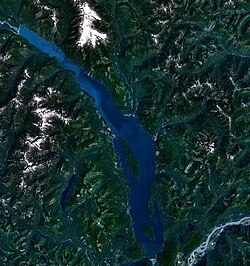
Harrison Lake
| Harrison Lake | |
|---|---|
 |
|
| Location | Coast Mountains, British Columbia |
| Coordinates | 49°30′N 121°50′W / 49.500°N 121.833°WCoordinates: 49°30′N 121°50′W / 49.500°N 121.833°W |
| Primary inflows | Lillooet River, Silver Creek |
| Primary outflows | Harrison River |
| Basin countries | Canada |
| Max. length | 60 km (37 mi) |
| Max. width | 9 km (5.6 mi) |
| Surface area | 218 km2 (84 sq mi) |
| Max. depth | 279 m (915 ft) |
| Water volume | 33 km3 (27,000,000 acre·ft) |
| Surface elevation | 10 m (33 ft) |
| Settlements | Harrison Hot Springs |
Harrison Lake is the largest lake in the southern Coast Mountains of Canada, being about 250 square kilometres (95 mi²) in area. It is about 60 km (37 mi) in length and at its widest almost 9 km (5.6 mi) across. Its southern end, at the resort community of Harrison Hot Springs, is c. 95 km east of downtown Vancouver. East of the lake are the Lillooet Ranges while to the west are the Douglas Ranges. The lake is the last of a series of large north-south glacial valleys tributary to the Fraser along its north bank east of Vancouver, British Columbia. The others to the west are the Chehalis, Stave, Alouette, Pitt, and Coquitlam Rivers.
At the north end of the lake is a small First Nations community of the In-SHUCK-ch Nation, Port Douglas, known in the St'at'imcets language as Xa'xtsa (ha-htsa). There are three hot springs along the shores of the lake or near it, including near Port Douglas, at Clear Creek, a tributary of Silver River, and at Harrison Hot Springs. Doctors Point on the lake's northwest shore was a village and Transformer site, with a large rock painting depicting either the spirit of the winds that rule travel on the lake, or a medicine man turned to stone by the Transformer.
...
Wikipedia
