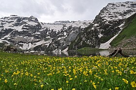
Harmukh Mountain
| Harmukh | |
|---|---|

Harmukh
|
|
| Highest point | |
| Elevation | 5,142 m (16,870 ft) |
| Prominence | 1,462 m (4,797 ft) |
| Coordinates | 34°24′00″N 74°54′30″E / 34.40000°N 74.90833°ECoordinates: 34°24′00″N 74°54′30″E / 34.40000°N 74.90833°E |
| Geography | |
| Location | Ganderbal, Kashmir Valley, India |
| Parent range | Himalayas |
| Climbing | |
| First ascent | 1856 by Thomas Montgomerie, United Kingdom |
| Easiest route | Arin Bandipore |
Harmukh (also known as Mount Haramukh or Harmukh mountain) is a mountain with a peak elevation of 5,142 metres (16,870 ft), in Ganderbal district of Jammu and Kashmir. Harmukh is part of the Himalaya Range, and is located between Nallah Sindh in the south and Kishanganga Neelum River in the north, rising above Gangabal Lake in the vicinity of Kashmir valley. It is mostly climbed from the northwestern side of Arin Bandipore.
Harmukh, with Gangbal Lake at its foot, is considered a sacred mountain by Hindus. According to kashmiri hindu theology, Harmukh is the abode of Lord Shiva. According to the legend of "Hurmukhuk Gosoni"
Harmukh lies in the northwestern Himalayan Range. The Karakoram Range borders it on the north and the Kashmir Valley on the south. Melt waters from glaciers form Gangabal Lake which lies at its foot to the north east side and contribute significantly to the regional fresh-water supply, supporting irrigation through Nallah Sindh. This Himalayan Range lies along the southern edge of the Eurasian tectonic plate and is made up of ancient sedimentary rocks (more than 390 million years old). Those strata were folded and thrust-faulted, and granite masses were intruded, when the Indian plate collided with Eurasia, beginning more than 100 million years ago. Harmukh means same on all sides. It is notable for its local relief as it is a consistently steep pyramid, dropping sharply to the east and south, with the eastern slope the steepest.
...
Wikipedia


