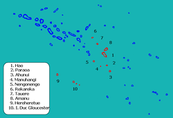
Hao (French Polynesia)

NASA picture of Hao Atoll
|
|
| Geography | |
|---|---|
| Location | Pacific Ocean |
| Coordinates | 18°4′31″S 140°56′43″W / 18.07528°S 140.94528°W |
| Archipelago | Tuamotus |
| Area | 720 km2 (280 sq mi) (lagoon) 47 km2 (18 sq mi) (above water) |
| Length | 50 km (31 mi) |
| Width | 14 km (8.7 mi) |
| Highest elevation | 3 m (10 ft) |
| Administration | |
|
France
|
|
| Overseas collectivity | French Polynesia |
| Administrative subdivision | Tuamotus |
| Commune | Hao |
| Largest settlement | Otepa |
| Demographics | |
| Population | 1066 (2012) |
| Hao | |
|---|---|

Flag of Hao
|
|
 |
|
| Coordinates: 18°04′31″S 140°56′43″W / 18.0753°S 140.9453°WCoordinates: 18°04′31″S 140°56′43″W / 18.0753°S 140.9453°W | |
| Country | France |
| Overseas collectivity | French Polynesia |
| Government | |
| • Mayor (2008–2014) | Suzanne Merehau |
| Area | 123 km2 (47 sq mi) |
| Population (2012)1 | 1,317 |
| • Density | 11/km2 (28/sq mi) |
| INSEE/Postal code | 98720 /98767 |
| Elevation | 0–3 m (0.0–9.8 ft) |
| 1Population without double counting: residents of multiple communes (e.g., students and military personnel) only counted once. | |
Hao, or Haorangi, is a large coral atoll in the central part of the Tuamotu Archipelago. It has c. 1000 people living on almost 50 km². It is used to house the military support base for the nuclear tests on Mururoa. Because of its shape, French explorer Louis Antoine de Bougainville named it Harp Island.
Hao is 920 km east of Tahiti. It is 50 km long and 14 km wide. The lagoon is the fourth largest atoll in French Polynesia (after Rangiroa, Fakarava, and Makemo) and has only one navigable passage, at Kaki, on the north end of the atoll where strong currents prevail up to 20 knots with bores. The lagoon covers an area of 720 km².
The climate is maritime, with temperatures oscillating between 23 and 32 °C throughout the year.
The chief town is the village of Otepa, where the main economic activity is the cultivation of pearls.
The first recorded European arriving on Hao was Pedro Fernández de Quirós on 10 February 1606. He named it Conversion de San Pablo. He was followed by José Andía y Varela in 1774.
Because of its shape, French explorer Louis Antoine de Bougainville named it Harp Island. In some maps it also appears as Bow Island.
Hao was the first atoll of the Tuamotus that Russian explorer Fabian Gottlieb von Bellingshausen visited in 1820 on the ships Vostok and Mirni.
In the late-1980s, two French intelligence (DGSE) operatives were briefly confined to the military base on the island after France obtained their release from a New Zealand prison for sinking the Greenpeace ship Rainbow Warrior. Their earlier-than-agreed-upon repatriation from the island by the French government became a diplomatic incident between New Zealand and France.
...
Wikipedia

