Hanumangarh district
|
Hanumangarh district हनुमानगढ़ जिला ਹਾਨੁਮੰਗੜ੍ਹ ਿੲਲਾਕਾ |
|
|---|---|
| District of Rajasthan | |
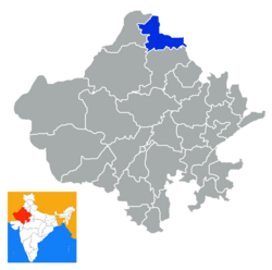
 Location of Hanumangarh district in Rajasthan |
|
| Country | India |
| State | Rajasthan |
| Administrative division | Bikaner Division |
| Headquarters | Hanumangarh |
| Area | |
| • Total | 12,645 km2 (4,882 sq mi) |
| Population (2011) | |
| • Total | 1,779,650 |
| Website | Official website |
Hanumangarh district is a district in the state of Rajasthan in India. The city of Hanumangarh is the district headquarters and its largest city.
The district is located in the extreme north of Rajasthan. It has an area of 12,645 km², a population of 1,779,650 (2011 census) and a population density of 184 persons/km². It is bounded on the north by Punjab state, on the east by Haryana state, on the south by Churu District of Rajasthan, and on the west by Ganganagar District of Rajasthan. The major work of the district is farming; major crops include rice, millet, cotton, sonamukhi,wheat, and vegetables.
This is the 31st district of Rajasthan. It was made as district on 12 July 1994 from Sri Ganganagar district. Earlier it was one of the Tehsils of Sri Ganganagar district.
The district contains the archaeological site of Kalibangan (Indus Valley Civilisation), and Pallu.
Hanumangarh also has Bhatner Fort which is considered to be one of the oldest forts of India.
According to the 2011 census Hanumangarh district has a population of 1,779,650, roughly equal to the nation of The Gambia or the US state of Nebraska. This gives it a ranking of 269th in India (out of a total of 640). Hanumangarh is one of the highest per capita income earning district in India.
...
Wikipedia
