Hans Island
| Disputed island Native name: Tartupaluk, ᑕᕐᑐᐸᓗᒃ Other names: Hans Ø, Île Hans |
|
|---|---|

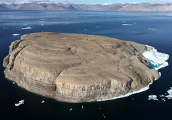
Hans Island from the east (Greenland) side
|
|
| Geography | |
 Map of part of Kennedy Channel, with the disputed Island. |
|
| Location | Kennedy Channel of the Nares Strait |
| Coordinates | 80°49′41″N 66°27′35″W / 80.82806°N 66.45972°WCoordinates: 80°49′41″N 66°27′35″W / 80.82806°N 66.45972°W |
| Area | 1.3 km2 (0.5 sq mi) |
| Length | 1,290 m (0.80 mi) |
| Width | 1,199 m (0.745 mi) |
| Claimed by | |
| Canada | |
| Denmark | |
| Demographics | |
| Population | Uninhabited |
Hans Island (Greenlandic: Tartupaluk; Inuktitut: ᑕᕐᑐᐸᓗᒃ; French: Île Hans; Danish: Hans Ø) is a small, uninhabited barren knoll measuring 1.3 km2 (0.5 sq mi), 1,290 metres (0.80 mi) long and 1,199 metres (0.745 mi) wide, located in the centre of the Kennedy Channel of Nares Strait—the strait that separates Ellesmere Island from northern Greenland and connects Baffin Bay with the Lincoln Sea. Hans Island is the smallest of three islands located in Kennedy Channel; the others are Franklin Island and Crozier Island. The strait is 35 kilometres (22 mi) wide here, placing the island within the territorial waters of both Canada and Denmark. A theoretical line in the middle of the strait goes through the island.
The island has likely been part of Inuit hunting grounds since the 14th century. It is claimed by Denmark on behalf of the Greenland self-government and also by Canada. In accordance with the Greenland home rule treaty, Denmark handles certain foreign affairs, such as border disputes, on behalf of the entire commonwealth. The nearest populated places are Alert, Canada (198 km/123 mi distance, pop. 0 to 5), Siorapaluk, Greenland (349 km/217 mi distance, pop. 68) and Qaanaaq, Greenland (379 km/235 mi distance, pop. 656).
...
Wikipedia
