Haninge Municipality
| Haninge kommun | ||
|---|---|---|
| Municipality | ||
|
||
| Country | Sweden | |
| County | ||
| Seat | Handen | |
| Area | ||
| • Total | 2,160.87 km2 (834.32 sq mi) | |
| • Land | 458.07 km2 (176.86 sq mi) | |
| • Water | 1,702.8 km2 (657.5 sq mi) | |
| Area as of January 1, 2014. | ||
| Population (December 31, 2016) | ||
| • Total | 85,693 | |
| • Density | 40/km2 (100/sq mi) | |
| Time zone | CET (UTC+1) | |
| • Summer (DST) | CEST (UTC+2) | |
| ISO 3166 code | SE | |
| Province | Södermanland | |
| Municipal code | 0136 | |
| Website | www.haninge.se | |
| Density is calculated using land area only. | ||
Haninge Municipality (Haninge kommun) is a municipality in in east central Sweden. Its seat is located in Handen, a part of the .
Haninge Municipality was formed in 1971 when Västerhaninge and Österhaninge were united.
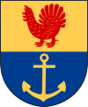
The municipal coat of arms depicts a capercaillie from which the name Haninge is believed to have been derived (the German word hahn means capercaillie), while the anchor symbolizes the naval base in the municipality. The German word usage is supposedly from the old German Hansa traders who operated in the area.
Haninge cherishes its nature, housing the southern parts of the scenic . There are over 3,600 islands, islets and skerries belonging to the municipality, with the three largest islands being Utö, Ornö and Muskö. A car tunnel, the longest in Sweden, connects Muskö to the mainland. The other two of the islands are reached with passenger and car ferries.
The scenic was built in Västerhaninge in 1985. It is the only temple of The Church of Jesus Christ of Latter-day Saints in Sweden. This temple is also the center of the LDS church in northern Europe.
There is a comparatively large Sweden-Finn community in Haninge which is estimated to be about 5% of the population.
The International Olympiad in Informatics (IOI) was held in Haninge in 1994.
The following sports clubs are located in Haninge Municipality:
The municipality is twinned with:
Coordinates: 59°10′N 18°08′E / 59.167°N 18.133°E
...
Wikipedia

