Hanging Rock, Ohio
| Hanging Rock, Ohio | |
|---|---|
| Village | |

Stone arch bridge over Osborne Run
|
|
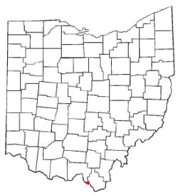
 Location of Hanging Rock, Ohio |
|
 Location of Hanging Rock in Lawrence County |
|
| Coordinates: 38°33′32″N 82°43′34″W / 38.55889°N 82.72611°WCoordinates: 38°33′32″N 82°43′34″W / 38.55889°N 82.72611°W | |
| Country | United States |
| State | Ohio |
| County | Lawrence |
| Area | |
| • Total | 0.65 sq mi (1.68 km2) |
| • Land | 0.56 sq mi (1.45 km2) |
| • Water | 0.09 sq mi (0.23 km2) |
| Elevation | 541 ft (165 m) |
| Population (2010) | |
| • Total | 221 |
| • Estimate (2012) | 221 |
| • Density | 394.6/sq mi (152.4/km2) |
| Time zone | Eastern (EST) (UTC-5) |
| • Summer (DST) | EDT (UTC-4) |
| ZIP code | 45638 |
| Area code(s) | 740 |
| FIPS code | 39-33194 |
| GNIS feature ID | 1075994 |
Hanging Rock is a village in Lawrence County, Ohio, United States, along the Ohio River. The population was 221 at the 2010 census. It is regularly labeled a speed trap as the state auditor reported $109,186 in mayor's court receipts in 2000 compared with $3,106 in property taxes.
Hanging Rock is a part of the Huntington-Ashland, WV-KY-OH, Metropolitan Statistical Area (MSA); it had a population of 288,649 at the 2000 census.
Hanging Rock had its start in 1820 when a blast furnace was built at the site. The village takes its name from a nearby cliff.
Hanging Rock is located at 38°33′32″N 82°43′34″W / 38.55889°N 82.72611°W (38.559021, -82.726070).
According to the United States Census Bureau, the village has a total area of 0.65 square miles (1.68 km2), of which 0.56 square miles (1.45 km2) is land and 0.09 square miles (0.23 km2) is water.
...
Wikipedia
