Hanging Hills
| Hanging Hills | |
|---|---|
| Metacomet Ridge | |

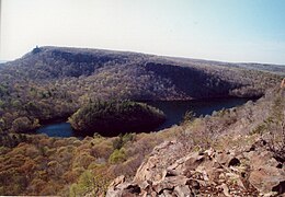
View of East Peak and Castle Craig from South Mountain, with Merimere Reservoir and Mine Island visible below
|
|
| Highest point | |
| Peak | West Peak |
| Elevation | 1,024 ft (312 m) |
| Dimensions | |
| Length | 3 mi (4.8 km) east-west |
| Geography | |
| Country | United States |
| State | Connecticut |
| Range coordinates | 41°34′N 72°49′W / 41.56°N 72.82°WCoordinates: 41°34′N 72°49′W / 41.56°N 72.82°W |
| Geology | |
| Age of rock | Triassic/ Jurassic |
| Type of rock | fault-block and igneous, sedimentary |
The Hanging Hills of south central Connecticut, United States are a range of mountainous trap rock ridges overlooking the city of Meriden and the Quinnipiac River Valley 900 feet (274 m) below. They are a sub-range of the narrow, linear Metacomet Ridge that extends from Long Island Sound near New Haven, Connecticut, north through the Connecticut River Valley of Massachusetts to the Vermont border. A popular outdoor recreation resource, the range is known for its microclimate ecosystems, rare plant communities, and expansive views from cliffs that rise abruptly over 700 feet (213 m) above the surrounding landscape. The Hanging Hills encompass the 1,800-acre (7.3 km2) Hubbard Park, designed with the help of landscape architect Frederick Law Olmsted. The 51 mile (80k) Metacomet Trail traverses the range.
Located within the towns of Meriden, Southington, and Berlin, the range, roughly horseshoe-shaped with cliff faces oriented south and west, includes, from east to west, Cathole Mountain 515 feet (157 m), South Mountain 767 feet (234 m), East Peak 976 feet (297 m), and West Peak 1,024 feet (312 m). Castle Craig is a small stone tower built in 1900 on East Peak. The Metacomet Ridge extends north from the Hanging Hills as Short Mountain and Ragged Mountain and southeast as Lamentation Mountain.
...
Wikipedia
