Hanaton
|
Hanaton חַנָּתֹן |
|
|---|---|

Hanaton, viewed from Tel Hanaton
|
|
| Coordinates: 32°47′8.51″N 35°14′38.39″E / 32.7856972°N 35.2439972°ECoordinates: 32°47′8.51″N 35°14′38.39″E / 32.7856972°N 35.2439972°E | |
| District | Northern |
| Council | Jezreel Valley |
| Affiliation | Kibbutz Movement |
| Founded | 1984 |
| Founded by | Conservative Jews |
| Population (2015) | 794 |
| Website | hannaton.co.il |
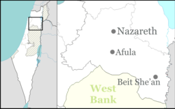
Hanaton (Hebrew: חַנָּתֹן, חנתון) is a kibbutz in northern Israel. Located twelve kilometers north of Nazareth near the Arab town of Shefaram, it falls under the jurisdiction of Jezreel Valley Regional Council. In 2015 it had a population of 794.
The biblical name Hanaton (Hebrew: חַנָּתֹן) appears in the Book of Joshua (19:14), where it is listed as in the area of the tribe of Zevulun, forming the border with the tribe of Asher's area.
Tel Hanaton, an archaeological site associated with the biblical location lies to the east of the kibbutz. The tel is in the western end of the Beit Netofa Valley, and covers an area of roughly 100 dunam (25 acres). It was occupied from the Bronze Age through the Ottoman Empire.
Kibbutz Hanaton overlooks Lake Eshkol, an important component of the National Water Carrier (Lake Eshkol is a 4.5 million m3 reservoir which Hanaton overlooks at the end of the Beit Netofa Canal). To the north of the kibbutz is the Arab village of Kafr Manda. Southwest of the kibbutz, across highway 79, lies Alon HaGalil.
...
Wikipedia

