Hanamaki, Iwate
|
Hanamaki 花巻市 |
|||
|---|---|---|---|
| City | |||

Hanamaki City Hall
|
|||
|
|||
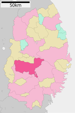
 Map of Iwate Prefecture with Hanamaki highlighted in pink |
|||
| Coordinates: 39°23′19″N 141°7′0.9″E / 39.38861°N 141.116917°ECoordinates: 39°23′19″N 141°7′0.9″E / 39.38861°N 141.116917°E | |||
| Country | Japan | ||
| Region | Tōhoku | ||
| Prefecture | Iwate | ||
| Area | |||
| • Total | 908.39 km2 (350.73 sq mi) | ||
| Population (September 2015) | |||
| • Total | 97,631 | ||
| • Density | 107/km2 (280/sq mi) | ||
| Time zone | Japan Standard Time (UTC+9) | ||
| City symbols | |||
| • Tree | Magnolia kobus | ||
| • Flower | Leontopodium | ||
| • Bird | Ural owl | ||
| Phone number | 0198-24-2111 | ||
| Address | 9-30 Kajo-cho, Hanamaki-shi, Iwate-ken 025-8601 | ||
| Website | Official website | ||
Hanamaki (花巻市 Hanamaki-shi?) is a city located in Iwate Prefecture, of the Tohoku region of northern Japan. As of September 2015, the city had an estimated population of 97,631 and a population density of 107 persons per km2. The total area was 908.39 square kilometres (350.73 sq mi). Hanamaki is famous as the birthplace of Kenji Miyazawa and for its hot spring resorts.
Hanamaki is located in central Iwate Prefecture, in the Kitakami River valley at the conflux of three rivers with the Kitakami River; the Sarugaishi-gawa from the east and the Se-gawa and Toyosawa-gawa from the west. In the west the city rises to the foothills of the Ou Mountains with the highest peak being Mt. Matsukura at 968 meters. To the east the city rises to the highest peak in the Kitakami Range, Mt Hayachine at 1917 meters. The largest reservoir is Lake Tase on the Sarugaishi River. Lake Hayachine on the Hienuki River is quite spectacular with steep mountains rising above it. Lake Toyosawa is in the western part of the city on the Toyosawa River. Parts of the city are within the borders of the Towada-Hachimantai National Park and the Hayachine Quasi-National Park. A chain of 12 hot springs that lie along the edge of the Ou Mountains form the Hanamaki Onsenkyo Village.
The area of present-day Hanamaki was part of ancient Mutsu Province, and has been settled since at least the Jomon period. During the Sengoku period, the area was dominated by various samurai clans before coming under the control of the Nambu clan during the Edo period, who ruled Morioka Domain under the Tokugawa shogunate.
...
Wikipedia


