Hamilton East—Stoney Creek
|
|
|||
|---|---|---|---|

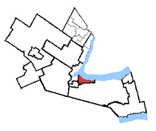
Hamilton East—Stoney Creek in relation to the other Hamilton area ridings
|
|||
| Federal electoral district | |||
| Legislature | House of Commons | ||
| MP |
Liberal |
||
| District created | 2003 | ||
| First contested | 2004 | ||
| Last contested | 2015 | ||
| District webpage | profile, map | ||
| Demographics | |||
| Population (2011) | 107,786 | ||
| Electors (2015) | 80,042 | ||
| Area (km²) | 72 | ||
| Pop. density (per km²) | 1,497 | ||
| Census divisions | Hamilton | ||
| Census subdivisions | Hamilton | ||
Hamilton East—Stoney Creek (French: Hamilton-Est—Stoney Creek) is a federal electoral district in Ontario, Canada, that has been represented in the Canadian House of Commons since 2004.
The riding was formed in 2003 from parts of the former ridings of Hamilton East and Stoney Creek.
Of the 115,709 constituents of the riding, a slight majority were previously constituents in the former riding of Stoney Creek. 58,462 constituents were part of the Stoney Creek riding while 57,247 constituents originated from Hamilton East.
This riding lost territory to Hamilton Centre during the 2012 electoral redistribution.
It consists of the part of the City of Hamilton lying north of the Niagara Escarpment and east of Ottawa Street.
The riding consists of the neighbourhoods of, Cherry Heights, Homeside, Normanhurst, McQuesten, Glenview, Rosedale, Red Hill, Vincent, Gershome, Greenford, Corman, Kentley, Riverdale, Parkview West, Parkview East, Nashdale, Lake Grayside and the eastern half of The Delta in the former City of Hamilton plus the part of the former City of Stoney Creek north of the Niagara Escarpment including the "Old Town", Fruitland and Winona.
This riding has elected the following Members of Parliament:
Coordinates: 43°15′03″N 79°48′15″W / 43.2507°N 79.8043°W
...
Wikipedia
