Hagerstown, Indiana
| Hagerstown, Indiana | |
|---|---|
| Town | |
 |
|
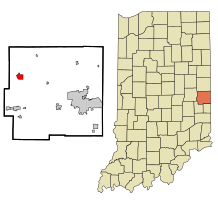
 Location in the state of Indiana |
|
| Coordinates: 39°54′41″N 85°9′38″W / 39.91139°N 85.16056°WCoordinates: 39°54′41″N 85°9′38″W / 39.91139°N 85.16056°W | |
| Country | United States |
| State | Indiana |
| County | Wayne |
| Township | Jefferson |
| Area | |
| • Total | 1.34 sq mi (3.47 km2) |
| • Land | 1.34 sq mi (3.47 km2) |
| • Water | 0 sq mi (0 km2) |
| Elevation | 1,040 ft (317 m) |
| Population (2010) | |
| • Total | 1,787 |
| • Estimate (2012) | 1,769 |
| • Density | 1,333.6/sq mi (514.9/km2) |
| Time zone | EST (UTC-5) |
| • Summer (DST) | EDT (UTC-4) |
| ZIP code | 47346 |
| Area code(s) | 765 |
| FIPS code | 18-30402 |
| GNIS feature ID | 452048 |
| Website | http://www.hagerstown.in.gov/ |
Hagerstown is a town in Jefferson Township, Wayne County, Indiana, United States. As of the 2010 census, the population was 1,787.
Hagerstown is located at 39°54′41″N 85°9′38″W / 39.91139°N 85.16056°W (39.911307, -85.160564). The town lies 61 miles (99 kilometers) ENE of Indianapolis, Indiana, 17 miles (27 kilometers) NW of Richmond, Indiana, and 63 miles (102 kilometers) WNW of Dayton, Ohio in the Midwestern region of the United States.
Terrain surrounding Hagerstown consists of flat land at an elevation of roughly 1000 feet above sea level that is used primarily for agriculture.
According to the 2010 census, Hagerstown has a total area of 1.34 square miles (3.47 km2), all land.
As of the census of 2010, there were 1,787 people, 751 households, and 467 families residing in the town. The population density was 1,333.6 inhabitants per square mile (514.9/km2). There were 826 housing units at an average density of 616.4 per square mile (238.0/km2). The racial makeup of the town was 97.7% White, 0.6% African American, 0.2% Native American, 0.3% Asian, and 1.2% from two or more races. Hispanic or Latino of any race were 0.8% of the population.
...
Wikipedia
