Hadsel
| Hadsel kommune | |||
|---|---|---|---|
| Municipality | |||
 |
|||
|
|||
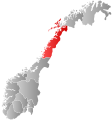
 Hadsel within Nordland |
|||
| Coordinates: 68°32′6″N 14°49′30″E / 68.53500°N 14.82500°ECoordinates: 68°32′6″N 14°49′30″E / 68.53500°N 14.82500°E | |||
| Country | Norway | ||
| County | Nordland | ||
| District | Vesterålen | ||
| Administrative centre | Stokmarknes | ||
| Government | |||
| • Mayor (2007) | Kjell Børge Freiberg (FrP) | ||
| Area | |||
| • Total | 566.44 km2 (218.70 sq mi) | ||
| • Land | 551.12 km2 (212.79 sq mi) | ||
| • Water | 15.32 km2 (5.92 sq mi) | ||
| Area rank | 188 in Norway | ||
| Population (2012) | |||
| • Total | 7,937 | ||
| • Rank | 129 in Norway | ||
| • Density | 14.4/km2 (37/sq mi) | ||
| • Change (10 years) | -2.4 % | ||
| Demonym(s) | Hadselværing | ||
| Time zone | CET (UTC+1) | ||
| • Summer (DST) | CEST (UTC+2) | ||
| ISO 3166 code | NO-1866 | ||
| Official language form | Bokmål | ||
| Website | www |
||
|
|
|||
Hadsel (Northern Sami: Válafierda) is a municipality in Nordland county, Norway. It is part of the traditional district of Vesterålen. The administrative centre of the municipality is the town of Stokmarknes. Other villages in Hadsel include Fiskebøl, Gjerstad, Grønning, Grytting, Hanøyvika, Hennes, Kaljord, Melbu, Sanden, and Sandnes.
The municipality is the southernmost municipality in the Vesterålen region. It is spread over four islands: Hadseløya, Hinnøya, Langøya, and Austvågøya. About 70% of the population live on Hadseløya island. Hadseløya island is connected to Langøya by the Hadsel Bridge and Børøy Bridge. Also, the Stokmarknes Airport, Skagen, is located nearby. It is the busiest small aircraft airport in Norway, serving 100,000 passengers annually (1997).
The municipality of Sortland lies to the north, Bø to the west, Vågan to the south, and Lødingen to the east.
...
Wikipedia


