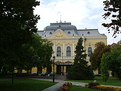
Hódmezővásárhely
| Hódmezővásárhely | ||
|---|---|---|

Hotel Black Eagle
|
||
|
||
| Location of Hódmezővásárhely | ||
| Coordinates: 46°25′49″N 20°19′08″E / 46.43039°N 20.31881°ECoordinates: 46°25′49″N 20°19′08″E / 46.43039°N 20.31881°E | ||
| Country | Hungary | |
| County | Csongrád | |
| Area | ||
| • Total | 483.22 km2 (186.57 sq mi) | |
| Population (2011) | ||
| • Total | 47,019 | |
| • Density | 97.87/km2 (253.5/sq mi) | |
| Time zone | CET (UTC+1) | |
| • Summer (DST) | CEST (UTC+2) | |
| Postal code | 6800 | |
| Area code(s) | 62 | |
Hódmezővásárhely (Hungarian pronunciation: [ˈhoːdmɛzøːvaːʃaːrhɛj]; Serbian: Вашархељ/Vašarhelj, Romanian: Ioneşti) is a city in south-east Hungary, on the Great Hungarian Plain, at the meeting point of the Békés-Csanádi Ridge and the clay grassland surrounding the river Tisza.
The city's name – which literally translates to Marketplace on the Beavers' Field – was first mentioned after the unification of two Árpád-era villages, Hód and Vásárhely – the former getting its name after Beaver's lake, an apocope term of Hód-tó (nowadays marking one of the city's districts and the canal Hód-tavi-csatorna), the latter Vásárhely coming from the medieval legal term marking the settlements with the right of hosting markets, literally meaning Market Town. The interim term mező, which also refers to the city's state as an oppidium – a city with certain rights given by its feudal ruler – was later added to the town and its name.
There is evidence of human habitation close to the modern town dating back 6,000 years, and archaeological evidence suggests that the area has been continuously inhabited since then by a variety of different cultures. Neolithic dwellings recessed into the ground stored domestic items such as plates, as well as the Kökénydombi Vénusz fertility symbol. Remains have also been found from the Copper Age, Bronze Age, Iron Age and the great migrations period. The town's archaeological treasures can now be seen at the permanent archaeological exhibition of the Tornyai János Museum.
...
Wikipedia


