Gzhatsk
| Gagarin (English) Гагарин (Russian) |
|
|---|---|
| - Town - | |
 Monument to Yuri Gagarin in the town |
|
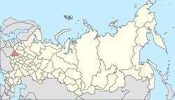
 Location of Smolensk Oblast in Russia |
|
|
|
|
|
|
|
|
|
|
| Administrative status (as of February 2014) | |
| Country | Russia |
| Federal subject | Smolensk Oblast |
| Administrative district | Gagarinsky District |
| Urban settlement | Gagarinskoye |
| Administrative center of | Gagarinsky District, Gagarinskoye Urban Settlement |
| Municipal status (as of May 2013) | |
| Municipal district | Gagarinsky Municipal District |
| Urban settlement | Gagarinskoye Urban Settlement |
| Administrative center of | Gagarinsky Municipal District, Gagarinskoye Urban Settlement |
| Mayor | Andrey Puzikov (acting) |
| Statistics | |
| Area (urban settlement) (February 2014) | 17.93 km2 (6.92 sq mi) |
| Population (2010 Census) | 31,721 inhabitants |
| Density | 1,769/km2 (4,580/sq mi) |
| Time zone | MSK (UTC+03:00) |
| Founded | 1718 |
| Town status since | 1776 |
| Previous names | Gzhatsk (until 1968) |
| Postal code(s) | 215010, 215059 |
| Dialing code(s) | +7 48135 |
|
|
|
| on | |
Gagarin (Russian: Гага́рин), known until 1968 as Gzhatsk (Гжатск), is a town and the administrative center of Gagarinsky District of Smolensk Oblast, Russia, located on the Gzhat River, 240 kilometers (150 mi) northeast of Smolensk, the administrative center of the oblast. Population: 31,721 (2010 Census);28,789 (2002 Census);28,867 (1989 Census).
The town's former name is from that of the Gzhat River, which is of Baltic origin (cf. Old Prussian gudde, meaning "forest").
In 1718, a village on the territory of modern Gagarin was transformed by a decree of Peter the Great to a transshipment landing stage (called Gzhatsky landing stage). From the mid-18th century, Gzhatsk was a sloboda, and in 1776, by a decree by Catherine the Great, it was granted uyezd town status and a coat of arms showing "a barge loaded with bread ready for departure, on a field argent", meaning that the town was a good landing stage for grain.
The town was built at the crossing of the Moscow road (east-west) and the Smolensk road (north-south, paralleling the river). By the plan of 1773, it was laid out in triangular form. One part paralleled the Gzhat River, another—the road to Moscow, and the base of the triangle connected them.
...
Wikipedia


