Gwinnett County, Georgia
| Gwinnett County, Georgia | |
|---|---|

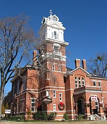
Gwinnett Historic Courthouse in Lawrenceville
|
|
 Location in the U.S. state of Georgia |
|
 Georgia's location in the U.S. |
|
| Founded | December 15, 1818 |
| Named for | Button Gwinnett |
| Seat | Lawrenceville |
| Largest city | Peachtree Corners |
| Area | |
| • Total | 437 sq mi (1,132 km2) |
| • Land | 430 sq mi (1,114 km2) |
| • Water | 6.4 sq mi (17 km2), 1.5% |
| Population (est.) | |
| • (2015) | 895,823 |
| • Density | 1,871/sq mi (722/km²) |
| Congressional districts | 4th, 7th, 10th |
| Time zone | Eastern: UTC-5/-4 |
| Website | www |
Gwinnett County is a county in the north central portion of the U.S. state of Georgia. As of the 2010 census, the population was 859,304, making it the second-most populous county in Georgia. Its county seat is Lawrenceville. The county is named for Button Gwinnett, one of the signers of the Declaration of Independence.
Gwinnett County is included in the Atlanta-Sandy Springs-Roswell, GA Metropolitan Statistical Area.
Created in 1818 by an act of the Georgia General Assembly, Gwinnett County was formed from parts of Jackson County (formerly part of Franklin County) and from lands gained through the cession of Indian lands. Named for Button Gwinnett, one of the signatories of the Declaration of Independence, the first county court was held at the home of Elisha Winn, and the county seat was placed at Lawrenceville.
In 1861, all three of Gwinnett County’s representatives at the Georgia Constitutional Convention (1861) in Milledgeville voted against secession. Towards the end of the war, several skirmishes took place in Gwinnett County as part of the Atlanta Campaign.
The northeastern part of Gwinnett County was removed to form a part of the new Barrow County in 1914.
According to the U.S. Census Bureau, the county has a total area of 437 square miles (1,130 km2), of which 430 square miles (1,100 km2) is land and 6.4 square miles (17 km2) (1.5%) is water.
...
Wikipedia
