Gusevsky District
| Gusevsky District Гусевский район (Russian) |
|
|---|---|
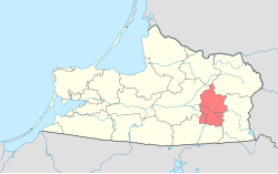
 Location of Gusevsky District in Kaliningrad Oblast |
|
| Coordinates: 54°35′N 22°12′E / 54.583°N 22.200°ECoordinates: 54°35′N 22°12′E / 54.583°N 22.200°E | |
 Gusev, Gusevsky District |
|
| Location | |
| Country | Russia |
| Federal subject | Kaliningrad Oblast |
| Administrative structure (as of November 2011) | |
| Administrative center | town of Gusev |
| Administrative divisions: | |
| Towns of district significance | 1 |
| Rural okrugs | 4 |
| Inhabited localities: | |
| Cities/towns | 1 |
| Rural localities | 40 |
| Municipal structure (as of May 2013) | |
| Municipally incorporated as | Gusevsky Urban Okrug |
| Statistics | |
| Area | 654.9 km2 (252.9 sq mi) |
| Population (2010 Census) | 37,142 inhabitants |
| • Urban | 76.1% |
| • Rural | 23.9% |
| Density | 56.71/km2 (146.9/sq mi) |
| Time zone | USZ1 (UTC+02:00) |
| Official website | |
| on | |
Gusevsky District (Russian: Гу́севский райо́н) is an administrative district (raion), one of the fifteen in Kaliningrad Oblast, Russia. As a municipal division, it is incorporated as Gusevsky Urban Okrug. It is located in the east of the oblast. The area of the district is 654.9 square kilometers (252.9 sq mi). Its administrative center is the town of Gusev. Population: 37,142 (2010 Census); 37,461 (2002 Census);7,533 (1989 Census). The population of Gusev accounts for 76.1% of the district's total population.
The district is situated in the east of the oblast and is sparsely populated. The rivers in the district include the Pissa and the Angrapa. The southern parts of the district are dominated by forests; in the northern parts forests and steppe pasture prevail.
Within the framework of administrative divisions, Gusevsky District is one of the fifteen in the oblast. The town of Gusev serves as its administrative center.
...
Wikipedia
