Gunnison River
| Gunnison River | |
| River | |
|
The Gunnison River in Black Canyon of the Gunnison National Park.
|
|
| Country | United States |
|---|---|
| State | Colorado |
| Tributaries | |
| - left | Tomichi Creek, Cebolla Creek, Lake Fork Gunnison River, Cimarron River, Uncompahgre River |
| - right | Smith Fork, North Fork Gunnison River, Kannah Creek |
| Cities | Gunnison, Grand Junction |
| Source | East River confluence with the Taylor River |
| - elevation | 8,008 ft (2,441 m) |
| - coordinates | 38°39′49″N 106°50′50″W / 38.66361°N 106.84722°W |
| Mouth | Colorado River |
| - elevation | 4,553 ft (1,388 m) |
| - coordinates | 39°3′42″N 108°34′42″W / 39.06167°N 108.57833°WCoordinates: 39°3′42″N 108°34′42″W / 39.06167°N 108.57833°W |
| Length | 180 mi (290 km) |
| Basin | 7,928 sq mi (20,533 km2) |
| Discharge | for Near Grand Junction |
| - average | 2,570 cu ft/s (72.8 m3/s) |
| - max | 35,200 cu ft/s (996.8 m3/s) |
| - min | 106 cu ft/s (3.0 m3/s) |
|
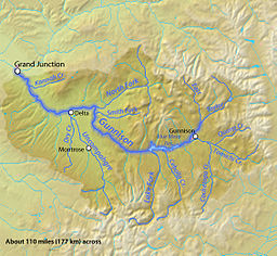
Map of the Gunnison River, its tributaries and major cities
|
|
The Gunnison River is a tributary of the Colorado River, 164 miles (264 km) long, in the Southwestern state of Colorado. It is the fifth largest tributary of the Colorado River, with a mean flow of 4,320 cu ft/s (122 m3/s).
The Gunnison River is formed by the confluence of Taylor and East rivers at Almont in eastern Gunnison County. Just past the town of Gunnison, the river begins to swell into the expanse of Blue Mesa Reservoir, a 36-mile-long (58 km) reservoir formed by Blue Mesa Dam, where it receives the Lake Fork of the Gunnison. Just downstream it is dammed again to form Morrow Point Reservoir, then just downstream of that dam for the final time to form Crystal Reservoir. The reservoirs produce hydroelectric power and supply water for the surrounding areas for both municipal and irrigation use. The reservoirs are the upper part of the Black Canyon of the Gunnison, one of the longest, narrowest, and deepest gorges in the world. Below Crystal Dam it begins to roar through massive cataracts and flows through the deepest part of the gorge. At the outlet of the canyon it receives the North Fork River, then downstream near Delta, Colorado is joined by the Uncompahgre River. It then winds through desert canyonlands, where it receives Kannah Creek before it empties out of the Dominguez Canyon into the Colorado in Grand Junction, some years rivaling the Colorado River for equal if not slightly less volume.
...
Wikipedia


