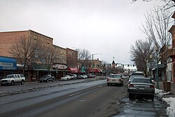
Delta, Colorado
| Delta, Colorado | |
|---|---|
| Home Rule Municipality | |

Main Street
|
|
| Nickname(s): City of Murals | |
 Location in Delta County and the State of Colorado |
|
| Coordinates: 38°45′27″N 108°05′17″W / 38.757372°N 108.087959°WCoordinates: 38°45′27″N 108°05′17″W / 38.757372°N 108.087959°W | |
| Country |
|
| State |
|
| County | Delta County Seat |
| Incorporated | October 24, 1882 |
| Government | |
| • Type | Home Rule Municipality |
| • Mayor | Edward Sisson |
| • Mayor Pro-Tem | Guy Pfalzgraff |
| Area | |
| • Total | 14.0 sq mi (36.3 km2) |
| • Land | 13.7 sq mi (35.6 km2) |
| • Water | 0.3 sq mi (0.7 km2) 2.02% |
| Elevation | 4,953 ft (1,486 m) |
| Population (2010) | |
| • Total | 8,915 |
| • Density | 649/sq mi (250.5/km2) |
| Time zone | MST (UTC-7) |
| • Summer (DST) | MDT (UTC-6) |
| ZIP code | 81416 |
| Area code(s) | 970 |
| INCITS place code | 0819850 |
| GNIS feature ID | 0185516 |
| Website | cityofdelta |
The City of Delta is the Home Rule Municipality that is the county seat and the most populous municipality of Delta County, Colorado, United States. The population was 8,915 at the 2010 census, up from 6,400 at the 2000 census. The United States Forest Service headquarters of the Grand Mesa, Gunnison, and Uncompahgre National Forests are located in Delta.
Delta was built as a trading post for the Ute people and early settlers. Fort Uncompahgre was built in 1828.
The town was named because of its location on the delta where the Uncompahgre River flows into the Gunnison River. The town was incorporated in 1882.
Delta is located in southwestern Delta County at 38°44′27″N 108°3′48″W / 38.74083°N 108.06333°W (38.740879, -108.063423). The downtown area is sited south of the Gunnison River and east of the Uncompaghre River. The city limits extend north across the Gunnison into the area now known as "North Delta", then west 6 miles (10 km) along U.S. Route 50 as far as Westwinds Airport.
...
Wikipedia
