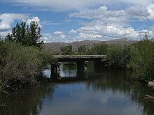
Tomichi Creek
| Tomichi Creek | |
|---|---|

Bridge over Tomichi Creek on the I Bar Ranch property
|
|
| Basin features | |
| Main source | 38°36′06″N 106°23′02″W / 38.60167°N 106.38389°W |
| River mouth | Confluence with Gunnison River 7,618 ft (2,322 m) 38°31′03″N 106°58′08″W / 38.51750°N 106.96889°WCoordinates: 38°31′03″N 106°58′08″W / 38.51750°N 106.96889°W |
| Progression | Gunnison—Colorado |
Tomichi Creek is a 71.8-mile-long (115.6 km)tributary of the Gunnison River in Gunnison County, Colorado. Tomichi Creek originates north and west of Monarch Pass and flows to the southwest along the base of Monarch Mountain. Congress Creek drains into Tomichi west of Old Monarch Pass where it flows south toward Sargents. Agape Creek flows into Tomichi just north of Sargents where Marshall Creek flows from Marshall Pass. Just below Sargents, Long Branch Creek, flowing out of Baldy Lake from the south, enters Tomichi Creek which takes a westward course where Needle Creek Reservoir drains into Tomichi east of Doyleville. Hot Springs Reservoir drains down Wanita Canyon flowing into Tomichi Creek just west of Doyleville. The Tomichi Valley is a semi-wide valley allowing Tomichi Creek to meander and split into several waterways creating an excellent livestock range and being largely private ranch lands. At Parlin, Quartz Creek flows from Pitkin and Ohio into Tomichi Creek. Tomichi continues its westward journey, slightly northwest, where the Cochetopa Creek drains into Tomichi at State Highway 114 from the south at the intersection of U.S. Highway 50 and continues west to Gunnison where it enters the Gunnison River. A map can be viewed at the BLM Colorado website here.
...
Wikipedia
