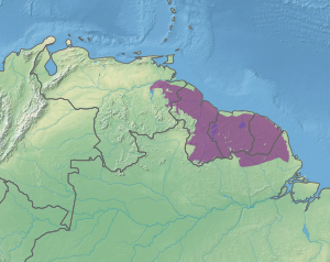
Guianan moist forests
| Guianan moist forests (NT0125) | |
|---|---|

Waterfall near Paramakatoi, Guyana
|
|

Location in South America
|
|
| Ecology | |
| Realm | Neotropical |
| Biome | Tropical and subtropical moist broadleaf forests |
| Geography | |
| Area | 512,817 km2 (198,000 sq mi) |
| Countries | Guyana, Suriname, French Guiana, Venezuela, Brazil |
| Coordinates | 3°59′24″N 57°10′48″W / 3.990°N 57.180°WCoordinates: 3°59′24″N 57°10′48″W / 3.990°N 57.180°W |
| Climate type | Af: equatorial, fully humid |
| Conservation | |
| Global 200 | Guianan moist forests |
The Guianan moist forests (NT0125) is an ecoregion in the east of Venezuela, north of Brazil and the Guyanas (Guyana, Suriname and French Guiana). It is in the Amazon biome. The climate is hot and humid, with two rainy seasons each year. As of 1996 the tropical rainforest habitat was relatively intact, although there were mounting threats from illegal logging and gold mining.
The Guianan Moist Forests ecoregion covers most of Guyana, Suriname, and French Guiana. It covers part of eastern Venezuela and parts of the north of the Brazilian states of Pará and Amapá. It has a total area of 51,281,764 hectares (126,720,000 acres).
Along the Atlantic coast to the east and northeast the ecoregion adjoins strips of Guianan Freshwater swamp forests, Amazon-Orinoco-Southern Caribbean mangroves and Orinoco Delta swamp forests. To the northwest it adjoins the Llanos ecoregion, the Guianan piedmont and lowland moist forests and Guianan Highlands moist forest. Scattered patches of this last ecoregion are found on higher ground within the Guianan Moist Forests ecoregion. To the southwest and in places along its southern border it adjoins large areas of Guianan savanna. Most of the southern border adjoins the Uatuma-Trombetas moist forests.
The ecoregion lies to the east of the lower Orinoco basin and covers about 65% of the northeast part of the ancient Guiana Shield. It is bounded to the south by the line of the Acarai and Tumuk Humak mountains, which defines the rim of the Amazon basin and the northern border of Brazil. A small part of the ecoregion in the east is in the lower Amazon basin. The Essequibo, Courantyne, Maroni and Oyapock rivers run through the region to the Atlantic Ocean.
...
Wikipedia
