Grovetown
| Grovetown, Georgia | |
|---|---|
| City | |
| Motto: A community that cares | |
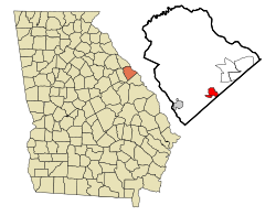
 Location in Columbia County and the state of Georgia |
|
| Coordinates: 33°26′58″N 82°11′49″W / 33.44944°N 82.19694°WCoordinates: 33°26′58″N 82°11′49″W / 33.44944°N 82.19694°W | |
| Country | United States |
| State | Georgia |
| County | Columbia |
| Area | |
| • Total | 4.83 sq mi (12.52 km2) |
| • Land | 4.82 sq mi (12.49 km2) |
| • Water | 0.01 sq mi (0.03 km2) |
| Elevation | 482 ft (147 m) |
| Population (2010) | |
| • Total | 11,216 |
| • Estimate (2016) | 13,463 |
| • Density | 2,326/sq mi (898.0/km2) |
| Time zone | Eastern (EST) (UTC-5) |
| • Summer (DST) | EDT (UTC-4) |
| ZIP code | 30813 |
| Area code(s) | 706 |
| FIPS code | 13-35716 |
| GNIS feature ID | 0356123 |
| Website | cityofgrovetown |
Grovetown is a city in Columbia County, Georgia, United States. It is part of the Augusta metropolitan area and the Central Savannah River Area. In the 2013 United States Census estimates, it had a population of 12,389. The mayor is Gary Jones.
Grovetown is located in southern Columbia County at 33°26′58″N 82°11′49″W / 33.44944°N 82.19694°W (33.449324, -82.196972). Downtown Augusta is 15 miles (24 km) east. The northern boundary of Fort Gordon is 2 miles (3 km) south.
According to the United States Census Bureau, Grovetown has a total area of 4.8 square miles (12.5 km2), of which 0.01 square miles (0.03 km2), or 0.23%, is water.
Georgia State Route 223 (SR 223) is known as Robinson Avenue from just northwest of Fort Gordon's Gate 2 to the intersection with Harlem–Grovetown Road and SR 388. It is known as Wrightsboro Road past this point. At this intersection, SR 388 takes on the Wrightsboro Road name until it meets Katherine Street. At this intersection, the highway turns left onto Horizon South Parkway, while Wrightsboro Road continues toward Augusta.
There are other important highways outside the city limits. Interstate 20 (Carl Sanders Highway), which leads west to Atlanta and east to Augusta and Columbia, S.C., is 2 mi (3.2 km) north. US 78/US 278/SR 10, known as Gordon Highway, is located just south of the city limits west of Fort Gordon's Gate 2, and runs between Harlem and Augusta. SR 383 (Jimmie Dyess Parkway), is 5 mi (8.0 km) east and connects Fort Gordon's Gate 1 to Evans.
...
Wikipedia
