Groom Lake, Nevada
| Homey Airport | |||||||||||||||||||
|---|---|---|---|---|---|---|---|---|---|---|---|---|---|---|---|---|---|---|---|

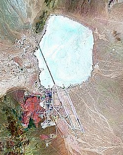
A satellite image, taken in 2000, shows dry Groom Lake just northeast of the site.
|
|||||||||||||||||||
| Summary | |||||||||||||||||||
| Airport type | Military Installation | ||||||||||||||||||
| Owner | U.S. Federal Government | ||||||||||||||||||
| Operator | United States Air Force | ||||||||||||||||||
| Location | Lincoln County, Nevada, U.S. | ||||||||||||||||||
| Elevation AMSL | 4,462 ft / 1,360 m | ||||||||||||||||||
| Coordinates | 37°14′06″N 115°48′40″W / 37.23500°N 115.81111°WCoordinates: 37°14′06″N 115°48′40″W / 37.23500°N 115.81111°W | ||||||||||||||||||
| Map | |||||||||||||||||||
| Location of Homey Airport | |||||||||||||||||||
| Runways | |||||||||||||||||||
|
|||||||||||||||||||
The United States Air Force facility commonly known as Area 51 is a highly classified remote detachment of Edwards Air Force Base, within the Nevada Test and Training Range. According to the Central Intelligence Agency (CIA), the correct names for the facility are Homey Airport (ICAO: KXTA) and Groom Lake, though the name Area 51 was used in a CIA document from the Vietnam War. Other names used for the facility include Dreamland, and nicknames Paradise Ranch,Home Base and Watertown. The special use airspace around the field is referred to as Restricted Area 4808 North (R-4808N).
The base's current primary purpose is publicly unknown; however, based on historical evidence, it most likely supports the development and testing of experimental aircraft and weapons systems (black projects). The intense secrecy surrounding the base has made it the frequent subject of conspiracy theories and a central component to unidentified flying object (UFO) folklore. Although the base has never been declared a secret base, all research and occurrences in Area 51 are Top Secret/Sensitive Compartmented Information (TS/SCI). In July 2013, following a Freedom of Information Act (FOIA) request filed in 2005, the CIA publicly acknowledged the existence of the base for the first time, declassifying documents detailing the history and purpose of Area 51.
Area 51 is located in the southern portion of Nevada in the western United States, 83 miles (134 km) north-northwest of Las Vegas. Situated at its center, on the southern shore of Groom Lake, is a large military airfield. The site was acquired by the United States Air Force in 1955, primarily for the flight testing of the Lockheed U-2 aircraft. The area around Area 51, including the small town of Rachel on the "Extraterrestrial Highway", is a popular tourist destination.
...
Wikipedia

