Nevada Test and Training Range
| Nevada Test and Training Range | |||||||||
Nellis Air Force Range
|
|||||||||
| military region | |||||||||
|
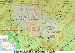
"Nellis Air Force Range" [sic] and nearby federal lands. The Tonopah Bombing Range (FUDS), Area A (MOA), Mellan Airstrip, Humboldt National Forest, Devil's Hole exclave of Death Valley National Park,Ash Meadows National Wildlife Refuge, and the NOAA climatology station at Las Vegas are not shown.
|
|||||||||
| Official name: The USAF uses "NTTR" and "Nevada Test and Training Range" to designate both the geographic area and the associated military unit. | |||||||||
| Name origin: Nevada, Nellis AFB, Las Vegas, & Tonopah | |||||||||
| Country | United States | ||||||||
|---|---|---|---|---|---|---|---|---|---|
| State | Nevada | ||||||||
| Counties | Nye, Lincoln | ||||||||
| Part of | "Nellis Air Force Base (NAFB) Complex" | ||||||||
| Borders on | Tonopah Bombing Range (FUDS) Nellis "Area A" |
||||||||
| Nearest city | Las Vegas | ||||||||
| GNIS location |
basin between Quartzite Mountain & the Belted Range |
||||||||
| - coordinates | 37°31′36″N 116°11′53″W / 37.52667°N 116.19806°WCoordinates: 37°31′36″N 116°11′53″W / 37.52667°N 116.19806°W | ||||||||
| Airspace Land area |
5,000 sq mi (12,950 km2) - restricted 7,000 sq mi (18,000 km2) - shared (MOA) 2012: 4,531 sq mi (11,740 km2) |
||||||||
| Established | September 29, 1940 | ||||||||
|
Range control units |
2011: NTTR military unit 2001: 98th Range Wing |
||||||||
| GNIS code | 2511961 | ||||||||
|
|
2012: 4,531 sq mi (11,740 km2)
1961: 7,249 sq mi (18,770 km2)
1957: 6,754 sq mi (17,490 km2)
1942: 6,997 sq mi (18,120 km2)
1941: 8,462 sq mi (21,920 km2)
1940: 5,560 sq mi (14,400 km2)
2001: 98th Range Wing
: 99th Range Group
…
1948:ATC Flying Division
c. 1945: Fifteenth Air Force
1942: Fourth Air Force detachment
1941:AFCC & WCACTC
The Nevada Test and Training Range (NTTR) is one of two military training areas used by the United States Air Force Warfare Center at Nellis Air Force Base in Nevada. The NTTR land area includes a "simulated Integrated Air Defense System", several individual ranges with 1200 targets, and 4 remote communication sites. The current NTTR area and the range's former areas have been used for aerial gunnery and bombing, for nuclear tests, as a proving ground and flight test area, for aircraft control and warning, and for Blue Flag, Green Flag, and Red Flag exercises.
The Nevada Test and Training Range land area is mostly Central Basin and Range ecoregion (cf. southernmost portion in the Mojave Desert), and smaller ecoregions (e.g., Tonopah Basin, Tonopah Playa, & Bald Mountain biomes) are within the area of numerous basin and range landforms of the NTTR.
...
Wikipedia

