Greenwich (town), New York
| Greenwich | |
|---|---|
| Town | |
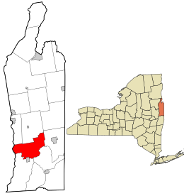
 Location in Washington County and the state of New York. |
|
| Coordinates: 43°07′54″N 73°28′38″W / 43.13167°N 73.47722°WCoordinates: 43°07′54″N 73°28′38″W / 43.13167°N 73.47722°W | |
| Country | United States |
| State | New York |
| County | Washington |
| Established | 1803 |
| Government | |
| • Town supervisor | Sara S. Idleman |
| Population (2000 Census) | |
| • Total | 4,896 |
| Time zone | EST (UTC-5) |
| ZIP code(s) |
12834 (primary)
|
| Area code(s) | 518 |
| Website | http://www.greenwichny.org/ |
Greenwich is a town in the southwest part of Washington County, New York, United States. The town is located on the west border of the county. The population was 4,896 at the 2000 census. It is part of the Glens Falls Metropolitan Statistical Area. Greenwich features several homes that were a part of the Underground Railroad.
The Town of Greenwich contains a village also named Greenwich.
The Horicon tribe is believed to be part of the early native population of the town.
Families began settling the area around 1763. The town was originally part of five land patents: Saratoga, Kettlehuyn, Cuyler, Campbell, and Argyle. The Town of Greenwich was formed from part of the Town of Argyle in 1803. In 1809, the community of Whipple City incorporated as a village and adopted the name Union Village. In 1867, the name was changed to Greenwich.
Greenwich views itself as having been an important location along the Underground Railroad. A historical marker was placed in Mowry Park detailing the locations of former safe houses.
The Greenwich and Johnsonville Railroad brought rail service to the area in 1870.
The Coffin Site was listed on the National Register of Historic Places in 1980.
According to the United States Census Bureau, the town has a total area of 44.4 square miles (114.9 km²), of which, 44.0 square miles (114.0 km²) of it is land and 0.4 square miles (0.9 km²) of it (0.81%) is water.
It lies within the Cambridge valley region in between the Adirondack Mountains and Green Mountain Range of Vermont.
...
Wikipedia
