Greenwald, Minnesota
| Greenwald, Minnesota | |
|---|---|
| City | |
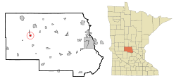
 Location of Greenwald within Stearns County, Minnesota |
|
| Coordinates: 45°36′N 94°52′W / 45.600°N 94.867°W | |
| Country | United States |
| State | Minnesota |
| County | Stearns |
| Area | |
| • Total | 0.72 sq mi (1.86 km2) |
| • Land | 0.72 sq mi (1.86 km2) |
| • Water | 0 sq mi (0 km2) |
| Elevation | 1,270 ft (387 m) |
| Population (2010) | |
| • Total | 222 |
| • Estimate (2016) | 224 |
| • Density | 310/sq mi (120/km2) |
| Time zone | Central (CST) (UTC-6) |
| • Summer (DST) | CDT (UTC-5) |
| ZIP code | 56335 |
| Area code(s) | 320 |
| FIPS code | 27-25874 |
| GNIS feature ID | 0644452 |
Greenwald is a city in Stearns County, Minnesota, United States. The population was 222 at the 2010 census. It is part of the St. Cloud Metropolitan Statistical Area.
Minnesota State Highway 4 serves as a main route in the community, and Interstate 94 is nearby.
A post office called Greenwald has been in operation since 1910. Greenwald is a name partially derived from German, wald meaning "forest".
According to the United States Census Bureau, the city has a total area of 0.72 square miles (1.86 km2), all of it land.
The city of Greenwald is located within Grove Township geographically but is a separate entity.
At the 2010 census, there were 222 people, 98 households and 66 families residing in the city. The population density was 308.3 inhabitants per square mile (119.0/km2). There were 104 housing units at an average density of 144.4 per square mile (55.8/km2). The racial makeup of the city was 100.0% White. Hispanic or Latino of any race were 0.9% of the population.
There were 98 households of which 23.5% had children under the age of 18 living with them, 62.2% were married couples living together, 1.0% had a female householder with no husband present, 4.1% had a male householder with no wife present, and 32.7% were non-families. 29.6% of all households were made up of individuals and 12.3% had someone living alone who was 65 years of age or older. The average household size was 2.27 and the average family size was 2.77.
...
Wikipedia
