Greenup County
| Greenup County, Kentucky | |
|---|---|

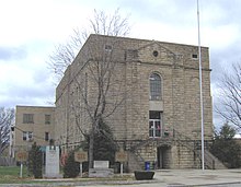
Greenup County courthouse in Greenup
|
|
 Location in the U.S. state of Kentucky |
|
 Kentucky's location in the U.S. |
|
| Founded | 1803 |
| Named for | Christopher Greenup |
| Seat | Greenup |
| Largest city | Flatwoods |
| Area | |
| • Total | 354 sq mi (917 km2) |
| • Land | 344 sq mi (891 km2) |
| • Water | 10 sq mi (26 km2), 2.8% |
| Population | |
| • (2010) | 36,910 |
| • Density | 107/sq mi (41/km²) |
| Congressional district | 4th |
| Time zone | Eastern: UTC-5/-4 |
| Website | greenupcounty |
Greenup County is a county located in the U.S. state of Kentucky. As of the 2010 census, the population was 36,910. The county was founded in 1803 and named in honor of Christopher Greenup. Its county seat is Greenup.
Greenup County is part of the Huntington-Ashland, WV-KY-OH Metropolitan Statistical Area.
Greenup County was formed by an act of the General Assembly of Kentucky on December 12, 1803 from Mason County which covered the majority of eastern Kentucky at the time.
Three courthouses have served Greenup County. The first courthouse, built of logs, was replaced by a brick structure in 1811.
The current officials of Greenup County are:
Greenup County is a part of the 20th Judicial Circuit (general jurisdiction) and the 20th Judicial District (limited jurisdiction) of the Kentucky Court of Justice (the state's unified court system), which also includes neighboring Lewis County. The officials in the 20th Judicial Circuit are:
The judge in the 20th Judicial District is:
Misdemeanor criminal cases brought in District Court are prosecuted by the County Attorney's office.
According to the U.S. Census Bureau, the county has a total area of 354 square miles (920 km2), of which 344 square miles (890 km2) is land and 10 square miles (26 km2) (2.8%) is water.
Like most eastern Kentucky counties, Greenup County is predominantly made up of rolling hills and valleys. The land in the Ohio River valley is generally flat and mostly populated by industry, commerce and residential development. Beyond this the land gives way to a series of hills and valleys that are representative of the foothills of the Appalachian Mountains and is relatively sparsely inhabited by farmers. Among these hills, popular fishing spots can be found among the Little Sandy River, Greenbo Lake, and Tygarts Creek. Greenup County's land is still predominantly covered by forest with minimal clear cutting of the old forests.
...
Wikipedia
