Greentop, Missouri
| Greentop, Missouri | |
|---|---|
| City | |

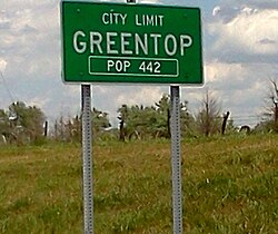
City limits sign
|
|
 Location within Schuyler County (left) and Missouri (right) |
|
| Coordinates: 40°20′54″N 92°34′2″W / 40.34833°N 92.56722°WCoordinates: 40°20′54″N 92°34′2″W / 40.34833°N 92.56722°W | |
| Country | United States |
| State | Missouri |
| Counties | Schuyler, Adair |
| Area | |
| • Total | 0.82 sq mi (2.12 km2) |
| • Land | 0.82 sq mi (2.12 km2) |
| • Water | 0 sq mi (0 km2) |
| Elevation | 984 ft (300 m) |
| Population (2010) | |
| • Total | 442 |
| • Estimate (2012) | 439 |
| • Density | 539.0/sq mi (208.1/km2) |
| Time zone | Central (CST) (UTC-6) |
| • Summer (DST) | CDT (UTC-5) |
| ZIP code | 63546 |
| Area code(s) | 660 |
| FIPS code | 29-29422 |
| GNIS feature ID | 0718830 |
Greentop is a city in Adair and Schuyler County, Missouri. The population was 442 at the 2010 census.
Greentop is considered one of the oldest communities in Schuyler County, with first settlement in the early 1840s. However the town layout was not documented until 1855. A U.S. Post Office was established in 1857, and the town was finally incorporated in February 1867.
Greentop is located at 40°20′54″N 92°34′2″W / 40.34833°N 92.56722°W (40.348360, -92.567281). According to the United States Census Bureau, the city has a total area of 0.82 square miles (2.12 km2), all of it land. A residential portion lies in Adair County while the majority of the town, including the business district, is in Schuyler County.
Greentop is part of the Kirksville Micropolitan Statistical Area.
As of the census of 2010, there were 442 people, 199 households, and 130 families residing in the city. The population density was 539.0 inhabitants per square mile (208.1/km2). There were 222 housing units at an average density of 270.7 per square mile (104.5/km2). The racial makeup of the city was 98.9% White, 0.7% Asian, 0.2% from other races, and 0.2% from two or more races. Hispanic or Latino of any race were 0.9% of the population.
...
Wikipedia
