Greensboro, Alabama
| Greensboro, Alabama | |
|---|---|
| City | |

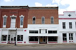
Main Street in Greensboro
|
|
 Location in Hale County and the state of Alabama |
|
| Coordinates: 32°42′8″N 87°35′46″W / 32.70222°N 87.59611°W | |
| Country | United States |
| State | Alabama |
| County | Hale |
| Area | |
| • Total | 2.39 sq mi (6.18 km2) |
| • Land | 2.38 sq mi (6.16 km2) |
| • Water | 0.008 sq mi (0.02 km2) |
| Elevation | 282 ft (86 m) |
| Population (2010) | |
| • Total | 2,497 |
| • Density | 1,050/sq mi (405.6/km2) |
| Time zone | Central (CST) (UTC-6) |
| • Summer (DST) | CDT (UTC-5) |
| ZIP code | 36744 |
| Area code(s) | 334 |
| FIPS code | 01-31720 |
| GNIS feature ID | 0157974 |
Greensboro is a city in Hale County, Alabama, United States. At the 2010 census the population was 2,497, down from 2,731 at the 2000 census. The city is the county seat of Hale County. It is part of the Tuscaloosa, Alabama Metropolitan Statistical Area.
Greensboro was incorporated as a town in December 1823 as "Greensborough". It was named in honor of American Revolutionary War general Nathanael Greene. The name was soon simplified to "Greensboro". The community was known as "Troy" prior to incorporation. Several sites on the National Register of Historic Places are in or near Greensboro. These include Glencairn, the Greensboro Historic District, Magnolia Grove, the McGehee-Stringfellow House, Millwood, and the Payne House.
Greensboro is slightly southeast of the center of Hale County and is crossed by Alabama State Routes 14, 25, and 69. SR 14 leads northwest 21 miles (34 km) to Eutaw and east 19 miles (31 km) to Marion. SR 25 leads northeast through Talladega National Forest 36 miles (58 km) to Brent and south 32 miles (51 km) to Thomaston. SR 69 leads north 38 miles (61 km) to Tuscaloosa and southwest 33 miles (53 km) to Linden. Demopolis is 25 miles (40 km) to the southwest via SR 69 and U.S. Route 80.
...
Wikipedia
