Eutaw, Alabama
| Eutaw, Alabama | |
|---|---|
| City | |

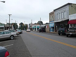
Downtown Eutaw, Alabama
|
|
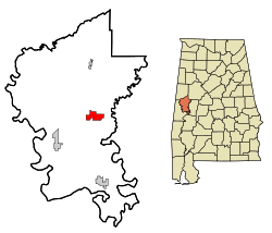
 Location in Greene County and the state of Alabama |
|
| Coordinates: 32°50′26″N 87°53′20″W / 32.84056°N 87.88889°WCoordinates: 32°50′26″N 87°53′20″W / 32.84056°N 87.88889°W | |
| Country | United States |
| State | Alabama |
| County | Greene |
| Government | |
| • Mayor | Raymond Steele |
| • City Council |
Members
|
| Area | |
| • Total | 12.0 sq mi (31.1 km2) |
| • Land | 11.9 sq mi (30.9 km2) |
| • Water | 0.08 sq mi (0.2 km2) |
| Elevation | 217 ft (66 m) |
| Population (2010) | |
| • Total | 2,934 |
| • Density | 246/sq mi (94.9/km2) |
| Time zone | Central (CST) (UTC-6) |
| • Summer (DST) | CDT (UTC-5) |
| ZIP code | 35462 |
| Area code(s) | 205 |
| FIPS code | 01-24664 |
| GNIS feature ID | 0118059 |
| Website | www |
Eutaw (/ˈjuːtɔː/ YEW-taw) is a city in Greene County, Alabama, United States. At the 2010 census the population was 2,934. The city is the county seat of Greene County and was named in honor of the Battle of Eutaw Springs, the last engagement of the American Revolutionary War in the Carolinas.
Schools in Eutaw include Robert Brown Middle School, Eutaw Primary School, and Greene County High School.
Eutaw was laid out in December 1838 at the time that Greene County voters chose to relocate the county seat from Erie, which was located on the Black Warrior River. It was incorporated by an act of the state legislature on January 2, 1841.
During the Reconstruction Era, Eutaw was the site of a number of Klan murders and rebellion acts. On March 31, 1870, the county solicitor, Alexander Boyd, was taken from his hotel and murdered by a group of Klan members (a self-avowed historian of the klan claims it was a group from Mississippi). In the fall of that same year, in the run-up to the gubernatorial election, after the killing of two black politicians in Greene County, the Eutaw riot took place outside the county courthouse, during which up to four blacks were killed by whites.
...
Wikipedia
