Greenland, NH
| Greenland, New Hampshire | ||
|---|---|---|

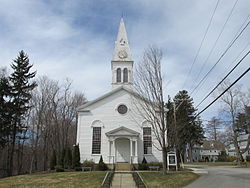
Community Congregational Church
|
||
|
||
 Location in Rockingham County and the state of New Hampshire. |
||
| Coordinates: 43°02′10″N 70°49′58″W / 43.03611°N 70.83278°WCoordinates: 43°02′10″N 70°49′58″W / 43.03611°N 70.83278°W | ||
| Country | United States | |
| State | New Hampshire | |
| County | Rockingham | |
| Incorporated | 1721 | |
| Government | ||
| • Board of Selectmen | Vaughan Morgan, Chair Jim Rolston Paul Sanderson Chester Deorocki Chip Hussey |
|
| • Town Administrator | Karen Anderson | |
| Area | ||
| • Total | 13.3 sq mi (34.4 km2) | |
| • Land | 10.5 sq mi (27.2 km2) | |
| • Water | 2.8 sq mi (7.3 km2) 21.07% | |
| Elevation | 59 ft (18 m) | |
| Population (2010) | ||
| • Total | 3,549 | |
| • Density | 270/sq mi (100/km2) | |
| Time zone | Eastern (UTC-5) | |
| • Summer (DST) | Eastern (UTC-4) | |
| ZIP code | 03840 | |
| Area code(s) | 603 | |
| FIPS code | 33-31700 | |
| GNIS feature ID | 0873612 | |
| Website | www.greenland-nh.com | |
Greenland is a town in Rockingham County, New Hampshire, United States. The population was 3,549 at the 2010 census. It is drained by the Winnicut River and bounded on the northwest by Great Bay.
One of the earliest settlements in the state, Greenland was a parish of Portsmouth (then called Strawbery Banke) operating in 1638. Captain Francis Champernowne moved from Strawbery Banke in 1640 and settled in the area of the present Portsmouth Country Club. Although it was originally to be called Canary, he would call his farm "Greenland". His extensive landholdings included a farm which is now the town of Madbury, named for his ancestral home in Devon, England.
Residents requested and were granted a separate parish in 1706. In c. 1710, Captain Samuel Weeks constructed a substantial brick house, thought to be the oldest brick house in New Hampshire still standing. It survived the 1755 Cape Ann earthquake. Only the 18" thick beams that supported the structure were cracked during the quake. Greenland would incorporate in 1721.
Greenland annexed parts of Stratham in 1805 and 1847.
According to the United States Census Bureau, the town has a total area of 13.3 square miles (34 km2), of which 10.5 sq mi (27 km2) is land and 2.8 sq mi (7.3 km2) is water, comprising 21.07% of the town. The highest point in Greenland is Breakfast Hill, at 151 feet (46 m) above sea level), on the town's border with Rye. Greenland abuts Great Bay to the north and is primarily drained by the Winnicut River. Greenland lies fully within the Piscataqua River (Coastal) watershed.
...
Wikipedia

