Greene County, NY
| Greene County, New York | |||
|---|---|---|---|

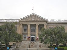
The Greene County Court House in Catskill, NY
|
|||
|
|||
 Location in the U.S. state of New York |
|||
 New York's location in the U.S. |
|||
| Founded | March 3, 1800 | ||
| Named for | Nathanael Greene | ||
| Seat | Catskill | ||
| Largest town | Catskill | ||
| Area | |||
| • Total | 658 sq mi (1,704 km2) | ||
| • Land | 647 sq mi (1,676 km2) | ||
| • Water | 11 sq mi (28 km2), 1.7% | ||
| Population | |||
| • (2010) | 49,221 | ||
| • Density | 76/sq mi (29/km²) | ||
| Congressional district | 19th | ||
| Time zone | Eastern: UTC-5/-4 | ||
| Website | www |
||
Greene County is a county located in the U.S. state of New York. As of the 2010 census, the population was 49,221. Its county seat is Catskill. The county's name is in honor of the American Revolutionary War general Nathanael Greene.
On March 25, 1800, Greene County was created by the partitioning of Albany (360 Square Miles) and Ulster (270 Square Miles) counties, producing a county of 620 square miles (1,600 km2).
On April 3, 1801, 90 square miles (230 km2) of land was transferred from Delaware and Ulster counties, raising the total area to 710 square miles (1,800 km2). This transferred Prattsville, Vly Mountain, Halcott Center, Bushnellsville, Highmount, Shandaken, Lanesville, and Pine Hill within Greene County.
On May 26, 1812, Greene County lost 20 square miles (52 km2) to Ulster County, lowering the total area to 690 square miles (1,800 km2), reassigning Pine Hill, Highmount, and Shandaken to Ulster County.
On April 15, 1814, the county borders were re-surveyed, and the line adjusted with no change in area.
On April 17, 1822, the border was again surveyed, with no change in area, but Palenville was found to be inside Greene County.
On April 23, 1823, the border was again resurveyed, and the Hudson River border with Columbia County realigned accordingly.
...
Wikipedia


