Green Valley, Arizona
| Green Valley, Arizona | |
|---|---|

Tile rooftop in Green Valley
|
|
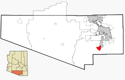
 Location in Pima County and the State of Arizona |
|
| Location in the United States | |
| Coordinates: 31°51′N 111°0′W / 31.850°N 111.000°WCoordinates: 31°51′N 111°0′W / 31.850°N 111.000°W | |
| Country | United States |
| State | Arizona |
| County | Pima |
| Area | |
| • Total | 26.3 sq mi (68.0 km2) |
| • Land | 26.2 sq mi (68.0 km2) |
| • Water | .04 sq mi (.1 km2) |
| Elevation | 2,980 ft (908 m) |
| Population (2010) | |
| • Total | 23,765 |
| • Density | 658.6/sq mi (254.3/km2) |
| Time zone | Mountain (MST) (UTC-7) |
| ZIP codes | 85614, 85622 |
| Area code(s) | 520 |
| FIPS code | 04-29710 |
| GNIS feature ID | 0037327 |
Green Valley is a census-designated place (CDP) in Pima County, Arizona, United States. The population was 23,765 at the 2010 census.
Green Valley is located along the western side of the Santa Cruz River at 31°51′N 111°0′W / 31.850°N 111.000°W (31.8556, -111.0001).Continental is to the east of Green Valley, on the other side of the river.
According to the United States Census Bureau, the CDP has a total area of 26.3 square miles (68.0 km²), of which, 26.2 square miles (68.0 km²) of it is land and 0.04 square miles (0.1 km²) of it (0.08%) is water.
Green Valley is twenty miles (32 km) south of Tucson and 40 miles (64 km) north of Nogales, Sonora, Mexico. Surrounded by copper mines, and near the cycling, hiking and birding areas of the Santa Rita Mountains, Green Valley is an unincorporated retirement community composed of 59 Homeowner Associations.
The largest of the mines are the Sierrita Mine owned by Freeport-McMoRan and the Mission Mine of ASARCO. Compared to other mines in Arizona the two mines are large; Sierrita is low-grade.
...
Wikipedia

